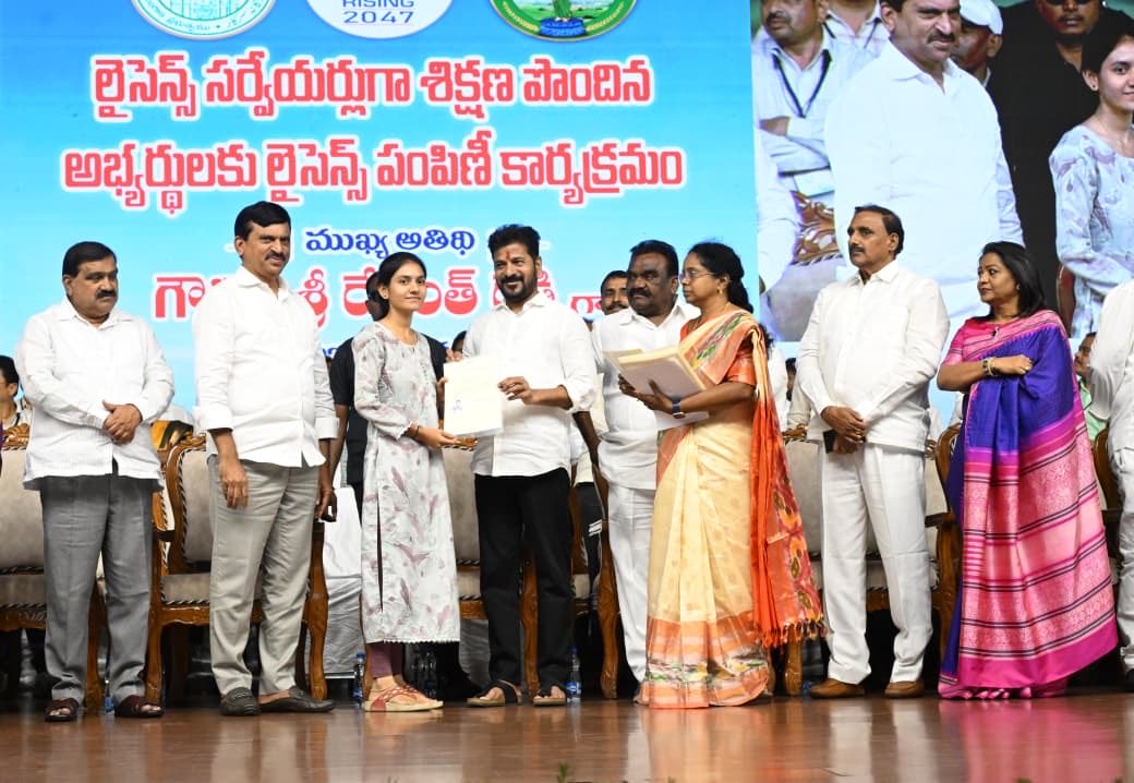
In the heart of Hyderabad’s bustling Shilpakala Vedika, a transformative moment unfolded on October 19, 2025, as Chief Minister A. Revanth Reddy spearheaded the distribution of licenses to over 3,465 newly trained surveyors. This ceremony, attended by Revenue Minister Ponguleti Srinivas Reddy, marked a pivotal step toward resolving longstanding land disputes that have plagued Telangana’s farmers for generations. With a vision to appoint up to 7,000 licensed surveyors across the state’s mandals—aiming for four to six professionals per administrative unit—the government signals its unwavering commitment to fortifying land services and empowering the agricultural backbone of Telangana.
Chief Minister Reddy’s impassioned address resonated deeply, urging these surveyors to embrace their role as guardians of the soil. “You must always stand by the farmers,” he declared, invoking the ethos of Rythu Raj—where the farmer reigns as king. He painted a vivid picture of integrity as the cornerstone of their work, warning that any injustice to a farmer equates to betraying one’s own kin. This event transcends a mere handout of certificates; it ignites a revolution in land management, promising to heal the wounds of boundary conflicts and propel Telangana toward its ambitious economic horizons.
As Telangana grapples with 1.6 crore acres of cultivable land riddled by unresolved disputes despite over a century of reforms, this initiative arrives at a critical juncture. Farmers, who form the lifeblood of this vibrant state, have long endured the shadows of unclear titles and contested borders. Now, armed with modern tools and governmental backing, licensed surveyors stand ready to delineate boundaries with precision, fostering trust and productivity in rural landscapes. This article delves into the ceremony’s significance, the Chief Minister’s blueprint for progress, and the broader implications for Telangana’s agricultural renaissance—all while highlighting how these efforts align with the state’s soaring Telangana Rising Vision 2047.
The Ceremony: Igniting Telangana’s Licensed Surveyors Initiative for Seamless Land Governance
The air at Shilpakala Vedika buzzed with anticipation as Chief Minister Revanth Reddy, flanked by Minister Ponguleti, took the stage to formally launch the license distribution. This wasn’t just an administrative ritual; it represented a seismic shift in how Telangana approaches land administration. Over 3,465 surveyors, meticulously selected and trained, received their credentials, each one a key to unlocking resolutions for thousands of pending cases.
Ponguleti Srinivas Reddy, in his review meeting prelude, emphasized the strategic deployment: one licensed surveyor per mandal initially, scaling up to ensure every village accesses expert boundary demarcation. This move addresses the bottlenecks in the existing system, where overburdened revenue officials often delay surveys, exacerbating farmer distress. By embedding professionals at the grassroots, the government accelerates the implementation of the Bhu Bharati Act, 2024, which mandates comprehensive land re-surveys to issue permanent Bhudaar cards—digital deeds that affirm ownership unequivocally.
Attendees, including eager surveyors and farmer representatives, witnessed Reddy’s hands-on approach as he personally handed over the first licenses. His words cut through the formalities: “We entrust you with this crucial responsibility as you step into villages and hamlets.” The ceremony doubled as a rallying cry, blending solemn oaths with optimistic projections. Videos from the event, capturing the Chief Minister’s dynamic delivery, quickly went viral on social media, amplifying the message to remote corners of the state.
This initiative builds on Telangana’s digital legacy. The erstwhile Dharani portal, launched in 2020 to digitize land records, faced criticism for glitches and inaccessibility, leaving many farmers in limbo. Enter Bhu Bharati, the upgraded platform that integrates blockchain for tamper-proof records and AI-driven dispute resolution. Licensed surveyors serve as the human interface, venturing into fields with GPS-enabled tools to map parcels accurately, reducing errors from manual entries. Early adopters report a 40% faster resolution rate in pilot mandals, a testament to the program’s potential.
As the evening unfolded, cultural performances celebrated Telangana’s agrarian heritage—folk dances depicting harvest joys interspersed with speeches on sustainable farming. The event concluded with a collective pledge: surveyors vowing to prioritize farmer welfare, aligning their compasses not just to coordinates but to the heartbeat of rural India. This ceremony, timed just before Diwali, symbolized a festival of lights for land rights, illuminating paths out of darkness for countless tillers of the soil.
Chief Minister’s Call to Action: Embracing Rythu Raj Ethos in Telangana’s Farmer Support Framework
Chief Minister Revanth Reddy’s speech masterfully wove personal anecdotes with policy imperatives, centering on the Rythu Raj philosophy—a mantra that elevates farmers to sovereign status in Telangana’s governance. “To truly uphold the title of Rythu Raj, honesty must guide your work,” he asserted, his voice steady yet fervent. He challenged the surveyors: treat every boundary as a family heirloom, for “doing injustice to a farmer is equivalent to doing injustice to your own family.”
This ethos traces back to the Rythu Bandhu scheme, Telangana’s flagship investment support program initiated in 2018 under the previous administration but revitalized by Reddy’s government. Under Rythu Bandhu, farmers receive Rs. 5,000 per acre per season—totaling Rs. 10,000 annually—directly into their accounts, bypassing intermediaries. Yet, Reddy envisions more: a holistic ecosystem where financial aid pairs with secure land tenure. Licensed surveyors embody this synergy, ensuring that aid reaches verifiable owners without the specter of disputes.
Reddy urged active participation in Telangana’s reconstruction, positioning surveyors as architects of progress. “If you work with integrity and commitment, you will bring great respect to Telangana,” he proclaimed. This call resonates amid rising farmer incomes, which climbed 15% in 2024 thanks to schemes like Rythu Bharosa—an enhanced version promising crop insurance and input subsidies. By resolving boundary issues, surveyors prevent the annual loss of Rs. 2,000 crore in disputed productivity, channeling resources back into irrigation and mechanization.
In a state where agriculture employs 45% of the workforce, such empowerment ripples outward. Women farmers, often inheriting fragmented plots, stand to gain most. Reddy highlighted gender-inclusive training for surveyors, ensuring sensitivity to cultural norms in joint family holdings. Stories from the field already emerge: a Warangal widow reclaiming her late husband’s 5-acre plot after a swift survey, or a Mahabubnagar cooperative expanding irrigation canals sans litigation.
Reddy’s rhetoric also subtly critiqued past lapses. Despite 140 years of land laws—from British-era settlements to post-independence reforms—disputes persist, costing the judiciary millions in backlog. He pivoted to hope: “We appoint you to ensure no farmer suffers due to boundary disputes.” This proactive stance aligns with national goals under Viksit Bharat, where secure land rights fuel Atmanirbhar villages.
Surveyors, fresh from rigorous six-month programs covering drone mapping and GIS software, now fan out to 33 districts. Their mandate? Not just demarcation but education—workshops teaching farmers to read Bhudaar cards and report anomalies via the Bhu Bharati app. Early metrics show a 25% uptick in voluntary dispute settlements, proving Reddy’s faith: integrity breeds respect, and respect yields prosperity.
Tackling Persistent Land Disputes: Unraveling Telangana’s Agricultural Boundary Challenges
Telangana’s 1.6 crore acres of arable land harbor treasures and tribulations alike. Fertile black soils in the Godavari basin yield bumper rice crops, while rain-fed tracts in Adilabad pulse with cotton and pulses. Yet, beneath this bounty lurks a web of disputes—over 5 lakh cases clogging revenue courts as of 2025. Chief Minister Reddy spotlighted this irony: even after 140 years of legislative tinkering, from the 1881 Madras Survey Act to the 2024 Bhu Bharati overhaul, ambiguities endure.
Historical scars fuel the fire. Colonial surveys prioritized revenue extraction, sketching hasty maps that ignored tribal encroachments. Post-1947, zamindari abolition fragmented holdings, birthing sub-divisions too minuscule for modern tractors. The 2014 state bifurcation inherited Andhra’s Dharani flaws—glitches freezing mutations, stranding farmers in digital purgatory.
Recent flare-ups underscore urgency. The Regional Ring Road (RRR) project, envisioned as a 350-km orbital highway, sparked protests in 2025 when alignments gobbled 20,000 acres across 163 villages. Farmers in Sangareddy and Yadadri rallied against perceived land grabs, detentions of BRS leaders amplifying cries for fair compensation. Reddy responded swiftly, urging out-of-court settlements: “Why do we need courts when dialogue suffices?”
Licensed surveyors emerge as neutral arbiters. Equipped with total stations and LiDAR tech, they retrace colonial lines with centimeter accuracy, cross-verifying against satellite imagery. In pilot zones like Nalgonda, re-surveys slashed disputes by 60%, freeing officials for development tasks. The Bhu Bharati Act mandates appeals within 90 days, with surveyors’ reports holding presumptive value in tribunals—streamlining justice from years to months.
Broader impacts beckon. Secure boundaries enable bank loans against land as collateral, unlocking Rs. 50,000 crore in untapped credit for Telangana’s 70 lakh farmers. They spur consolidation, merging tiny plots into viable farms for drip irrigation and hybrid seeds. Environmentally, precise mapping curbs illegal encroachments on wetlands, preserving biodiversity in the Deccan plateau.
Challenges persist: resistance from vested interests and tech illiteracy in remote hamlets. Yet, Reddy’s administration counters with mobile vans—survey units on wheels—and toll-free helplines. By August 15, 2026, the government targets zero-pending disputes in 50 mandals, a moonshot mirroring Kerala’s 2031 elimination pledge. Surveyors, as frontline warriors, hold the sextant to this horizon.
The Emotional Bond: Land as Sacred Heritage in Telangana’s Farming Culture
Chief Minister Reddy evoked a profound truth: “Just as the people of Telangana hold deep affection for their mothers, they share the same emotional bond with their land.” This poetic analogy captures the soul of Telangana’s agrarian ethos, where soil isn’t mere dirt but a lineage etched in sweat and stories.
In villages from Khammam to Karimnagar, land whispers ancestors’ tales. A farmer in Siddipet might till the same furrow his grandfather broke, each clod a chapter of resilience against droughts and monsoons. Disputes fracture this bond, sowing seeds of despair—families splintered over inches, harvests lost to litigation.
Licensed surveyors inherit a sacred duty: safeguarding these boundaries as custodians of heritage. Reddy framed it thus: “You bear the responsibility of protecting their ownership.” Their work transcends metrics; it mends emotional rifts. Imagine a young couple in Medak, inheriting a contested plot— a surveyor’s map restores not just acres but ancestral pride.
This reverence informs policy. The Rythu Raj extends beyond cash to cultural affirmation—festivals like Sankranti now include land literacy drives, where surveyors demo apps amid bonfires. Women’s self-help groups, numbering 40,000 statewide, partner in mapping, claiming stakes in matrilineal traditions.
Psychologically, clarity heals. Studies show disputed land correlates with 30% higher stress in rural households; resolutions boost mental health metrics akin to therapy. Surveyors, trained in empathetic engagement, listen before they measure—validating narratives that GPS alone can’t capture.
As Telangana urbanizes, this bond faces dilution. Youth migrate to Hyderabad’s IT corridors, leaving elders to guard plots. Surveyors bridge generations, digitizing oral histories into Bhudaar metadata. Reddy’s vision? A state where land’s emotional pull anchors progress, preventing the alienation seen in other bifurcated states.
Government’s Bold Vision: Decoding Telangana Rising Vision 2047 for Sustainable Development
At the ceremony’s core pulsed Telangana Rising Vision 2047—Reddy’s magnum opus for a $3 trillion economy by India’s centennial. Unveiled at NITI Aayog, this roadmap charts exponential growth: $1 trillion by 2034, propelled by agri-tech, green energy, and skill hubs.
Reddy rallied surveyors: “Your cooperation and integrity are vital” to these milestones. How? Secure land unlocks investments—pharma parks in Genome Valley need uncontested acres; solar farms in Anantapur demand verified leases. The vision spotlights “smart villages,” integrating IoT for precision farming, where surveyors’ baselines enable data overlays.
Citizen surveys, launched October 2025, infuse inclusivity—over 10 lakh responses shape pillars like women empowerment (target: 50% agri-leadership roles) and innovation (AI labs in every district). Agri-prosperity features prominently: doubling yields via climate-resilient crops, backed by Rs. 20,000 crore in subsidies.
Surveyors catalyze this. Their mappings feed the vision’s digital twin—a virtual Telangana for scenario planning. By 2047, the state eyes 20 million jobs, half in rural economies fortified by dispute-free lands. Reddy’s address tied it personally: “We aim to make Telangana the top-performing state.” With surveyors as enablers, this isn’t hyperbole—it’s a blueprint etched in fertile earth.
The Pivotal Role of Licensed Surveyors in Resolving Agricultural Boundary Disputes Across India
Zooming nationally, land surveyors wield transformative power in India’s patchwork of 14 crore hectares under plow. Boundary skirmishes, claiming 20% of civil suits, stall development—farmers forgo expansions fearing overlaps.
In Telangana, they pioneer solutions. Using EDM instruments, they adjudicate with forensic precision, admissible in courts. This mirrors successes in Maharashtra, where surveyor-led drives cut disputes 50% post-2020. Tools like drones slash costs 70%, democratizing access for smallholders.
Challenges abound: monsoon-eroded markers, forged deeds. Yet, training in ethics—à la Reddy’s mandate—ensures impartiality. Future-wise, AR glasses could overlay historical maps in real-time, revolutionizing fieldwork.
Telangana’s model exports nationally, influencing SVAMITVA drones in other states. Surveyors don’t just draw lines; they redraw destinies, turning contested frontiers into frontiers of opportunity.
Background on Telangana’s Agricultural Landscape: From Deccan Plateau to Global Grain Baskets
Telangana’s farms paint a mosaic: 52% net sown area, dominated by paddy (40 lakh hectares) and maize. The Deccan plateau’s basalt soils retain moisture, birthing hybrids that feed 8 crore mouths. Yet, fragmentation—average holding 1.2 hectares—hobbles efficiency.
Irrigation covers 45%, via projects like Kaleshwaram, but disputes divert funds. Surveyors rectify this, enabling micro-plot optimizations. Climate change bites: erratic rains slash yields 15%; resilient mapping aids adaptive zoning.
Government infusions—Rythu Bandhu‘s Rs. 65,000 crore since inception—boost, but tenure security multiplies returns. With surveyors, Telangana eyes export hubs, rivaling Punjab’s wheat prowess.
Evolution of Land Records: Journey from Dharani Portal to Bhu Bharati Revolution
Dharani, 2020’s digital dawn, digitized 2 crore records but stumbled on mutations—farmers queued virtually for months. Glitches fueled protests; revenue dipped as sales halted.
Bhu Bharati, 2024’s phoenix, deploys Aadhaar-linked verification and ML for fraud detection. Surveyors operationalize it, conducting door-to-door validations. Part-B adjudications—legacy claims—now resolve in 60 days, up from years.
This evolution safeguards against benami holdings, channeling benefits to genuine tillers. By 2026, full coverage promises a dispute-free ledger, turbocharging Vision 2047.
Farmer Protests and Resolutions: Navigating Recent Land Acquisition Tensions in Telangana
2025’s RRR saga epitomized friction: alignments through fertile belts ignited marches, with BRS alleging favoritism to corporates. Farmers demanded surveys before seizures; Reddy acquiesced, deploying teams to reroute sparing 5,000 acres.
Similarly, Bharat Future City faced pushback; the CM mediated village sabhas, yielding amicable pacts. These episodes underscore surveyors’ mediation role—facilitating negotiations with irrefutable data.
Minister Ponguleti’s August 15 deadline for resolutions galvanized action, resolving 1 lakh cases. Protests wane as trust builds, proving dialogue plus demarcation disarms dissent.
Future Prospects: How Licensed Surveyors Will Reshape Rural Telangana’s Economic Fabric
Envision 2030: surveyors helm Agri-Digital Mandals, where apps predict yields from boundary data. Vision 2047‘s $3T dream hinges on this—agri-GDP doubling to 25%, jobs surging in agro-processing.
Challenges like skill gaps yield to upskilling; incentives—performance bonuses—retain talent. Collaborations with ISRO refine satellite surveys, minimizing fieldwork.
Ultimately, surveyors forge equity: small farmers access markets via consolidated co-ops, women lead via titled plots. Reddy’s legacy? A Telangana where land disputes are folklore, and farmers’ plows carve trillion-dollar tales.
Conclusion: A New Dawn for Telangana’s Farmers Under Rythu Raj Leadership
Chief Minister Revanth Reddy’s license distribution at Shilpakala Vedika heralds an era of precision and promise. By empowering surveyors to champion Rythu Raj, Telangana dismantles dispute barriers, nurturing its 1.6 crore acres toward abundance. As Telangana Rising Vision 2047 unfolds, these professionals stand as pillars—mapping not just land, but a future of dignity and dynamism. Farmers, long kings in name, now claim their throne in deed. The revolution sows today; tomorrow, it reaps a thriving state.