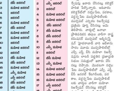
Jangaon Municipality, Jangaon District – Division of Jangaon Municipality into thirty (30) wards – Final Notification
Director of Municipal Administration, Telangana, Hyderabad has stated that, the Commissioner, Jangaon Municipality has submitted a proposal for division of Jangaon Municipality into thirty (30) wards after following the due procedure as prescribed in G.O. 1 st read above and requested to issue final notification.
After careful examination of the matter and in supersession of orders issued vide reference 2nd read above, Government hereby decide to issue final notification of division of Jangaon Municipality into thirty (30) wards.
The following Notification will be published in an Extra-Ordinary Issue of the Telangana Gazette:
Jangaon Municipality NOTIFICATION
In exercise of the powers conferred by sub-section (1) of section 6 of the Telangana Municipalities Act No. 11 of 2019 read with Telangana Municipalities (Division of Municipalities into wards) Rules 2019, issued in G.O.Ms.No.78, Municipal Administration and Urban Development (MA) Department, Dated 29.06.2019, the Governor of Telangana hereby notify the division of Jangaon Municipality into thirty (30) wards as described in the Annexure appended to the notification with immediate effect.
JANGAON MUNICIPALITY JANGAON DISTIRCT DESCRIPTION OF WARDS BOUNDARIES Jangaon Municipality Ward No.01:
Rajeev Nagar Colony Sy.Nos 88, 89, 90 & 91 of Chitakodur (V) & Sy.Nos 195, 196, 198, 199, 200 & 201 of Yeshwanthapur (V).
BOUNDARIES:
WEST: Starts from H.No. 5-3-129 and runs along the railway track up to Municipal Boundary runs along with Sy.No’s 89,90, 91 Chitakodur Village and up to Sy.No.200/1 of Yeshwanthapur Village.
Starts from Sy.No.200/1 of Yeshwanthapur Village at Railway track and runs upto Hanamkonda road along with Sy.No’s 200, 201, 198 & 196 Yeshwanthapur Village.
Starts from Sy.No’s 196 of Yeshwanthapur Village at Hanamkonda road and runs towards South West direction up to Fire Station office crossing.
Starts from Fire station office and runs along with vide 60′-0″ vide existing
Master plan road up to H. No. 5-4-130 and turns towards East direction up
to Il. No.5-4-134 and again turns towards northern direction up to H.No.5-4-110 and turns towards North-East corner upto H.No. 5-3-29 and turns towards North direction and runs along with 60′ vide existing Master Plan road upto Railway track.
Jangaon Municipality Ward No: 2.
6-1-1 to End of the block. 6-3-1 to 6-3-45.
Yellamma temple area with Sy.No’s 191, 192, 193 & 194 of Yeshwanthapur Village.
BOUNDARIES: NORTH: Starts from existing Hanamkonda main road and runs upto the corner point of Sy.No.192 of Yashwanthapur Village where the limits end.
EAST: Starts from boundary line of Sy.No.191 and runs towards southern side upto Yellamma temple and continues upto Udumula Hospital. From where runs towards south upto H.No.6-1-35/ 2.
SOUTH: Starts from H.No.6-1-35/2 and runs towards existing Suryapet-Jangaon
main road upto H.No.6-3-45, and turns towards west and runs upto H.No. 6-3-1.
WEST: H. No.6-3-1 runs towards north all along the existing Hanamkonda main road upto the corner point of Sy.No.192 where the Municipal limits end.
Jangaon Municipality Ward No.3.
6-3-46 to-Lind of the block 6-2-1 to 6-2-7/4.
BOUNDARIES:
NORTH: Starts from H.No.6-3-1 and runs towards East upto H.No 6-3-45 and touching Suryapet road upto H.No.6-1-35/2, where the Municipal limits end.
EAST: Starts from I-I.No.6-1-35/2 and runs towards South and runs on South East direction upto end of Municipal limits adjoining 100′ proposed master plan road.
SOUTH: Starts from Municipal limits adjoining 100′ proposed master plan road and turns towards West and runs through Sy.No’s 203, 224, 242, 246 & 247 upto nearby H.No.6-2-7/4.
WEST:
Jangaon Municipality Ward No.4 Starts from nearby H.No.6-2-7/4 and will take a turn towards North all along the existing 100′ main road upto H.No 6-3-1.
6-2-7/4/1 to End of the block. 2-8-124/1 to End of the block.
WEST: Starts from H.No.6-2-7/4 on Hanamkonda-Hyderabad main road and runs towards East direction upto the junction point of proposed 100′ road on the end of Municipal limits.
Starts from junction point of proposed 100′ road on the end of Municipal limits and turns towards southwest corner and turns towards southeast direction and runs upto proposed 100′ road.
Starts from proposed 100′ road at the end of Municipal limits and runs all along the proposed 100′ road towards southwest corner crossing the 100′ Hanamkonda-Hyderabad main road where the municipal limits end from where turns towards northwest direction upto Railway track.
Starts from southwest corner of Railway track and turns towards North and runs all along the Railway track upto north corner of Sy.No.400 and
turns towards east corner of Sy.No.400 and runs upto the proposed 40′ road. From there, runs all along the 40′ road towards east and meets the junction point at 60′ ft Nehru park to Housing Board colony road. Again it runs along 40ft road of Nagarjuna Teachers colony approved layout and meets 100′ existing Hanamkonda Hyderabad main road. From there, runs towards north along the existing 100′ main road upto H.No 6-2-7/4 at the starting point.
Jangaon Municipality Ward No.05
1-2-251 to 1-2-329/1 1-12-1 to End of the block 1-13-1 to End of the block
WEST: Starts from H.No 1-2-329/1 and runs towards south-east direction until reaches BSNL office at H.No 1-2-250/1.
Starts BSNL office at H.No 1-2-250/1 and runs in southern direction all along the 60′ proposed M.P road until reaches junction point of 60′ M.P road behind Banapuram Vidhyanagar colony and further turns towards eastern direction along 60′ M.P road until reaches railway track.
Starts from Railway track and runs along the track and further runs along the track in southern direction until reaches municipal limits.
Starts from corner point of railway track at end of municipal limits in Sy.No 426 and runs in North-West direction until reaches municipal limits in Sy.No 429.
Jangaon Municipality Ward No.6:
1-1-1 to End of the Block 1-2-1 to 1-2-88 1-2-89 to 1-2-250 1-2-355 to End of the Block 1-9-1 to 1-9-31 1-3-1 to 1-3-70/12
EAST: Starts from H.No. 1-3-70 and runs towards eastern direction upto junction point nearby Old C’I’O office area and turns southern direction upto H.No 1-9-19 and turns towards eastern direction and runs all along the road upto railway track beside Tahsildar office at H.No 1-1-1.
Starts from Railway track behind Tahsildar office and runs in the southern direction all along the track until reaches junction point at 60′ M.P road behind Banapuram Vidhyanagar Colony.
SOUTH: Start from junction point at 60′ M.P road behind Banapuram Vidhyanagar Colony and runs towards western direction until reaches junction point of 60′ M.P roads.
WEST: Starts from junction point of 60′ M.P roads and runs towards northern direction all along the 60′ M.P road until reaches BSNL office at Siddipet
BOUNDARIES:
road at H.No 1-2-250/1 and further crosses Siddipet PWD road and runs along the road beside Mulsim grave yard until reaches H.No 1-9-19.
Jangaon Municipality Ward No.07:
1-9-32 to End of the Block 1-10-1 to 1-10-64/36 1-10-72/9/3 to 1-10-130 BOUNDARIES:
NORTH: Starts from junction point at Grain Market area near H.No. 1-10-72/9/3 and runs along the Electricity office area until reaches the Railway track.
EAST: Railway track and runs in southern direction and runs along the track until reaches nearby H.No 1-1-1.
SOUTH: Starts from nearby H.No. 1-1-1 beside Tahsildar office and runs towards western direction until reaches 1-3-119 and further runs east direction until reaches junction point at Old CTO office area upto H.No. 1-10-140.
WEST: Starts from H.No 1-10-140 and runs towards North East direction all along the ABV school compound.
Jangaon Municipality Ward No.08:
1-3-71 to End of the Block 1-2-330 to 1-2-354 1-4-140/2 to lind of the Block 4-2 to 4-27 Aravinda Nagar & Sy.Nos 126,127,128,131,132,142,143 & 144(P) of Shameerpet Village.
4-30 to 4-35 of Vikas Nagar & Sy.Nos 141, 144 (P), 145, 146, 147, 148, 149 & 179 of Shamirpet Village. BOUNDARIES:
NORTH: Starts from Sy. No.132 at Municipal Limits and runs along the Municipal limits upto Sy. No.33.
EAST: Starts from Municipal limits and runs towards Southern direction along the Sy. No. 30, 31, 28, 25 and upto H.No. 1-4-160 and runs in the road Southern direction from Il.No. 1-4-166 and upto H.No. 1-4-190 and again turns towards Southern direction proceeds along Wadlakonda road upto H.No. 1-4-140/2.
SOUTH: Starts from H.No. 1-4-140/2 and runs along the boundary of ABV school until reaches junction point of ABV Degree college and ABV school and further runs along Degree college road until reaches junction point at H.No 1-3-70/1 and further runs in southern direction upto Siddipet PWD road.
WEST: Starts from Munsif court and runs towards western direction along Siddipet road until reaches H.No 1-2-330 and then crosses the PWD road and runs all along the merged boundary of Merged Shamirpet Village.
Jangaon Municipality Ward No.09:
1-5-1 to End of the Block 1-6-1 to end of the block
WEST: Starts from Sy. No.33 at Municipal Limits and runs along the Municipal limits upto Sy.No.39.
Starts from Municipal limits and proceeds towards Southern direction along the Southern boundary of Sy. No.39,38 and then turns east along proposed 50ft master plan road until it reaches the juflctiOn point of Chitakodur koad. Further, it runs in the southern diréttiOh along 60ft Chitäkodur Road upto Grain Market Junction.
Starts from Grain Market Junction and runs in the Hortherh diféction utpo I.No. 1-6-59 and runs tOwards Western diVection upto VISIO. t-6-91.
Starts fi-on-m I l.No. 1-6-91 and proceeds Iowards NoilinérH difdclion upco I-NO. 1-4-190 and again proceed töwards H.No. 1-5-1 and Proceed same direction along Eastern boundary of Sy. No. 25, 27, 28, 31 and 30 upto Municipal limits.
Jangaon Municipality Ward No.10:
1-7-1 to End of the Block 1-8-1 to End of the Block
1-10-142/3 to 1-10-142/3-5 1-10-64/37/1 to 1-10-72/9/2 1-10-181 to end of the block BOUNDARIES:
NORTH: Starts from H.No. 1-6-92 and runs towards Eastern direction upto burial ground.
EAST: Starts from burial ground at Laxmibaikunta and runs towards South eastern side up to Grain Market Junction.
SOUTIX: Starts from Grain Market Junction and runs along the 50ft road towards Southern direction upto H.No 1-10-64/37/1.
WEST: Starts from H.No. 1-10-64/37/1 and runs towards North West direction upto H.No. 1-6-91 at Wadlakonda road.
Jangaon Municipality Ward No.ll:
1-10-131 to 1-10-142/2 1-10-143 to 1-10-180 1-11-92/11, 1-11-92/15, 1-11-92/2/3, 1-11-92/10, 1-11-92/12, 1-11-92/13, 1-11-92/6, 1-11-92/6/2, 1-11-92/9, 1-11-92/9/1.
WEST: Starts from Sy. No.39 at Municipal limits and runs along the Municipal limits upto Sy.No.46 at Cheetakodur road.
Starts from Municipal limits and runs towards Southern direction along the Sy. No.’s 45, 48, 44, 43 and upto H.No. 1-10-161/1 at railway track.
Starts from H.No. 1-10-161/1 at railway track and runs along railway track towards South West direction upto H.No.1-10-130.
Starts from H.No. 1-10-131 and proceeds towards North West direction upto Grain Market junction and proceed towards east direction all along the 60ft Chitakodur road and turns left at 60ft proposed master plan road
upto boundaries of Sy. No. 38, 39, where it turns towards east and runs upto the Municipal limits.
Jangaon Municipality Ward No.12:
SOUTH: Starts from Sy. No.46 at Cheetakodur road and runs along the Municipal limits upto Sy.No.52 at railway track.
Starts from Sy. No.52 at Ylunicipal limits and upto railway track.
Starts from Sy. No.90/1 at Railway track and runs along the railway track upto H.No.1-11-1 at Douglas School.
WEST: H.No. 1-11-1 at Douglas School and runs towards Northern direction upto Municipal limits along the Sy. No. 45, 48, 44, 43 and upto 46.
Jangaon Municipality Ward No.13:
WEST: Starts from l l. No.4-9-13 at Railway track and runs towards Eastern direction upto Il.No.5-2-1x
Starts from I I.No.5-2-1 and runs towards southern direction up to junction point of 60′ Master plan road and 40′ Master plan road of TNGOs colony.
Starts from junction point of 60′ Master plan road and 40′ Master plan road of ‘l’NGOs colony and runs towards western side up to fish pond and runs towards south up to junction point at stadium and runs towards western direction up to I-I.No.4-10-47 and again runs towards southern direction up to Venkateshwara swamy temple junction and runs towards western direction up to junction point of Z.P. High School.
Starts from junction point at Z.P. High School and runs towards northern direction all along 40′ Master plan road up to railway track.
Jangaon Municipality Ward No.14:
BOUNDARIES:
NORTH: Starts from I l.No.5-2-140 and runs towards eastern direction up to proposed 60′ Master plan road.
EAST: Starts from junction point of Railway Iråck and i•uns fOWåi•ds south all along 60′ Master Élan road up to H.No.5-3-j.
söÜti4: Starts from VI.No.5-3-1 and runs towards SöUth-WeSl dihéctioit ålong 33′ Master plan road tip to ILNo.5-l-137/l.
WEST: Starts near H.No.5-1-137/1 and runs towards north up to Junction point of 60′ Master plan road and 40′ Master plan road of TNGOs colony.
Jangaon Municipality Ward No.15:
5-1-1 to End of the block 5-2-113/5, 5-2-130/ a, 5-2-135/8-A to 5-2-135/35
4-11-1 to End of the block
NORTH: Starts from H.No.4-11-10/1 and runs around the stadium up to H.No.411-65 and runs towards east up to 60′ Master Plan road.
EAST: Starts from south east corner (Govt. Jr. College) and runs towards south up to Housing board office Junction Near H.No.5-1-137/1 and runs towards north eastern direction to H.No.5-4-111 and runs towards south up to Fire Station Office.
SOUTH: Starts from Fire State Office and runs towards west upto Chaman Junction.
WEST: Starts from Chaman Junction and runs towards northern direction all along 40′ master plan road and further runs up to H.No.4-11-10/1.
Jangaon Municipality Ward No.16:
WEST: Starts from H. No. 4-12-1 and runs towards Eastern direction up to H.No.4-12-65 and turns towards northern direction up to nearby H.No. 410-13 and runs towards eastern direction up to junction point at stadium.
Starts at junction point of stadium and runs towards southern direction up to I I.No.4-10-112 and runs towards western direction upto H.No. 4-13-21.
Starts from H.No.4-13-20 and runs towards southern direction and reaches 50′ Master Plan road and runs towards west all along 50′ Master plan road upto I-I.No.4-12-22.
Starts from H. No. 4-12-22 and runs towards ZPSS school in Northern direction upto H. No. 4-12-1.
Jangaon Municipality Ward No.17:
NORTH: Starts from I I. No. 4-6-84/4 and runs towards eastern direction and takes turn towards southern direction upto H. No. 4-6-84/4 and again taken turn towards eastern direction and runs towards Sanjay Nagar Chaman, Police Quarters and upto PWD Hanamkonda road.
EAST: Police Quarters and runs towards Devi theater along PWD road upto I-I. No. 4-5-58.
SOUTH: Starts from Il. No. 4-5-58/11 at PWD Ilanamkonda road and runs towards Sy. No.97 and turns towards western direction and runs through the sy. No’s. 119, 107, 105, 103 upto H. No. 4-5-5.
WEST: Starts from H. No. 4-5-5 and runs towards towards
Burial ground I)harmakancha and upto I-I. No. 4-6-84/4.
Jangaon Municipality Ward No.18:
WEST: Starts from I l. No. 4-5-1 and runs towards Eastern direction along with Sy. No. 119, 107, 105, 103 and up to Sy. No. 97 and turns towards PWD Hyderabad road.
Starts from H. No. 4-5-59 at PWD Hanamkonda road and runs towards southern direction upto back side of Bus Depot H. No. 4-5-61/3.
Starts from PWD Hanamkonda road i.e. H. No. 4-5-61/3 and runs towards western direction up to H. No. 2-10-88/30 and take turns towards southern direction upto H. No. 2-11-1 and again turns towards western direction upto Pochamma temple.
Starts from Pochamma temple and runs towards North direction along
with Subash statue and Hanuman temple upto Venkannakunta cross road at 11. No. 4-5-1.
Jangaon Municipality Ward No.19:
NORTH: Starts from l l. No. 2-10-88/30 and runs towards Ekashila Public School and upto I I. No. 2-10-82 (existing well).
EAST: Starts from back side of Bus Depot at Hanamkonda road and runs towards RTC chowrastha.
SOUTH: Starts from RIC chowrastha and runs towards West direction upto Opp:
D.S.P. Office i.e. 11. No. 3-1-20.
WEST: Starts from H. No. 3-1-20 and turns towards Eastern difection up to H. No. 3-1-33/1 and again turns towards Northern direction up to Pochamnia temple and tUrns towards eastern diréetiOh and Funs uptö H. No. 2-10-9 and again turns tOwarås Northei•in direction di-id runs upto 11.No. 2-10-88/30.
Jangaon Municipality Ward NO.20
NORTH: Starts from ll. No. 2-7-123/2 and runs towards Eastern direction along with PWD road upto RTC chowrastha.
EAST: Starts from RTC chowrastha and runs towards I-lyderabad road near Bharath Gas Company.
SOUTH: Starts from Hyderabad PWD road to back side of Bharath Gas company.
WEST: Starts from back side of Bharath gas company and runs towards Kurmawada along with 40′ existing road upto H.No.2-7-123/2 at PWD road.
Jangaon Municipality Ward No.21
WEST: Starts from H. No. 2-6-61 and runs along with PWD Bus stand road up to
H. No.2-6-123.
Starts from H. No.2-6-123 runs along with 40′ wide road bp to 60′ road at H.N0. 2-6-91/2
Starts from H. No. 2-6-91/2 and runs towards Sy. No. 345, 352, 357 and up to 373.
Starts from Sy. No. 373 and runs towards H. No. 2-5-90/9 and up to PWD
Bus stand road H. No. 2-6-61.
Jangaon Municipality Ward No.22
SOUTH: Starts from I-I.No.2-8-1/6-7 and runs towards southeast and joins I lanamkonda-Hyderabad main road near H.No.2-8-16/6/12.
Starts from H.No.2-8-16/6/12 and turns towards extreme south and runs all along the road upto H.No.2-8-124.
Starts from H.No.2-8-124 and runs towards west all along the 40ft road of Nagarjuna teachers colony and turns towards North and runs all along the 40ft road and turns left near community hall road and runs upto junction point of 60ft existing road and further runs upto boundary of sy.N0 402 .
WEST: corner of Sy.No.402 and runs along Southern boundary of Sy.No 395, 384, 374, 373 and turns towards Northern direction and runs through SY.No 352 , 343 & 345 upto PWD road and turns towards southern directions and runs along PWD Hyderabad road upto HMT tractor showroom.
Ward No.23:
2-5-1 to 2-5-90/8
BOUNDARIES:
NORTH: Starts from Old railway gate and runs towards Eastern direction along with PWD road upto 1–1.No. 2-4-1 and turns towards North direction and runs towards Shivalayam temple upto H.No. 2-4-15 and again turns towards Eastern direction upto H.No. 2-4-20 and turns towards Southern direction along the Nehru park road upto H.No. 2-4-112 and turns towards Eastern direction upto H.No.2-5-45.
EAST: Starts from H.No. 2-5-45 and runs towards Southern direction upto H.N0.2-5-90/8.
SOUTH: Starts from H.No. 2-5-90/8 and runs towards Western direction upto railway track through Sy. No. 398, 403.
WEST: Starts from railwav track at Sy. No. 403 and runs towards Northern direction along the railway track upto old railway gate.
Jangaon Municipality Ward No.24:
NORTH: Starts from H.No.2-2-69 and runs towards eastern direction upto H.No. 23-97 and turns towards northern direction nearby H.No.2-2-1 and again turns towards eastern direction along the Police station, Gadi bazar, Water tank.
EAST: Starts from Il.No. 3-4-81 and runs towards Southern direction upto Railwav Station road and turns towards south and meets the Jangaon Siddipet PWD road.
SOUTH: Starts from Jangaon Siddipet road towards Western direction along with PWI) road upto H.No.2-2-134.
WEST: Starts from H.No. 2-2-134 and runs towards Northern direction upto
11.No.2-2-100.
Jangaon Municipality Ward No.25:
turns towards Eastern direction upto H.No. 3-4-73 and again turns towards Northern direction upto H.No.3-3-65 and again turns towards Eastern direction upto Ll.No.3-3-56 and turns towards Northern side upto H.No. 3-2-48/1 and again turns towards Eastern side and runs towards Ganesh street upto H.No. 3-2-18.
WEST: Starts from H.No. 3-2-18 and runs towards Southern direction along the Mahankali street, Krishna Kalamandir upto H.No. 3-1-41.
Starts from I-I. No. 3-1-41 and runs towards Western direction upto H.No. 3-1-20 along with H.No. 3-1-22 and turns towards Western side along the PWD road Nehru park area upto H.No. 3-4-15.
Starts from Il.No. 3-4-15 and runs towards Northern direction upto
11.No.3-4-28.
Jangaon Municipality Ward No.26:
NORTH: Starts from H. No. 3-8-93 and runs towards Eastern side upto H. No. 3-8-66 and turns towards Southern direction upto H. No. 3-8-69 and gain turns towards Eastern direction upto H. No. 3-9-60 and again turns towards Northern direction upto H. No. 4-2-47/2 and again turns towards Eastern direction upto Venkannakunta road i.e. H. No. 4-339/12/2.
EAST: Starts from H. No. 4-3-39/12/2 and runs towards Southern direction along with Venkannakunta B.’I’ road Hanuman temple up to H. No.
SOUTH: Starts from H. No. 3-6-88 and runs towards Westérn side along the Ganesh street, Gadibazar road and Police station road upto H. No.
3-7-95.
WEST: Starts from I I. No. 3-7-95 and runs towards North direction upto H.NO. 3- 8-93.
Jangaon Municipality Ward No.27:
NORTH: Starts from IL No.3-9-1 and runs towards eastern direction up to H.No.38-32.
EAST: Starts from H. No.3-8-32 and runs towards southern direction until reaches El.No.3-9-28 (Near Govt. Jr. [Girls] College) and crosses 50′
railway station road and further runs towards southern direction up to
11.No.2-2-100.SOUTH: I l. No.2-2-100 and runs towards western direction upto
11.No.2-1-59.
WEST: Starts from H.No.2-1-59 and runs towards northern direction all along the Mosque up to railway junction at H.No.2-1-1 and further runs towards north-east direction from YI.No.3-11-1 up to H.No.3-11-20.
Jangaon Municipality Ward No.28:
WEST: Starts from railway track at I l. No. 3-11-21 and runs towards North East direction along with railway track upto H. No. 4-2-103.
Starts from H. No. 4-2-103 at railway track and turns towards eastern direction up to Il.No. 4-2-67/1 and turns towards southern direction along with C.C. road upto I I.No.4-2-47/2.
Starts from H. No. 4-2-47/2 and runs towards Western direction upto H. No. 4-1-32/1
Starts from H. No. 4-1-32/1 and turns towards Northern direction upto H.No. 4-1-31 and turns towards Western direction upto railway track.
Jangaon Municipality Ward No.29:
NORTH: Starts from H. No. 4-2-112/1 at railway track and runs towards Eastern side along with railway track upto Slaughter house.
EAST: Starts from slaughter house at railway track and runs towards Southern side upto H. No.4-4-30/1 and turns towards Eastern direction upto H. No.4-4-43 and again turns towards Southern direction along the Burial ground compound wall upto I-I. No.4-3-39/12/2.
SOUTH: Starts from H. No. 4-3-39/12/2 and runs towards Western direction up to
WEST: Starts from H. No. 4-2-47/2 and runs towards Northern direction upto H.No.4-2-67/1 and turns towards western direction upto H.No.4-2-111 and again turns towards northern direction upto railway track.
Jangaon Municipality Ward No.30:
BOUNDARIES:NÖIOH: Starts from I I. No. 4-4-9 al railway track loivards, Eåslern directiöil alölåg with 60′ voåd €télo I l. No.4-8-58.
WEST: Starts from H. No.4-8-58 at railway track and runs towards southern direction up to H.No.4-7-45 and runs towards eastern direction up to H.No.4-7-99 and turns towards southern direction upto H.No.4-8-86.
Starts from H. No-4-8-86 and runs towards western direction all along 50′ road upto H. No.4-6-84/2 and turns towards northern direction up to I I.No.4-6-85 and turns towards west up to H.No.4-6-3 and further runs up to H.No.4-8-30.
Starts from H.No.4-8-30 and runs all along the 40′ Master plan road up to H.No.4-8-9 wherein reaches the railway track.
426 Dated:17.12.2019Read the following: –
- G.O.Ms.No.78, MA & I-JD (MA.I) Department, dated 29.06.2019.
- G.O.Ms.No.108, MA & UD (MA. 1) Department, dated 07.07.2019.
- G.O.Rt.No.795, MA & UD (MA.I) Department, dated 03.12.2019.
- From the DMA, Telangana, Hyderabad. Lr.Roc.No.161149/2019/ Election. 1, Dated: 17.12.2019.