Alair Municipality, Yadadrai-Bhongir District Division of Alair Municipality into Twelve (12) wards Final Notification – Orders Director of Municipal Administration, Telangana, Hyderabad has stated that, the Commissioner, Alair Municipality has submitted a proposal for division of Alair Municipality into Twelve (12) wards after following the due procedure as prescribed in G.O. 1 st read above and requested to issue final notification.
Alair municipality candidates list 2020
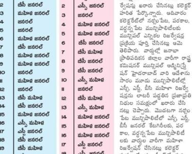
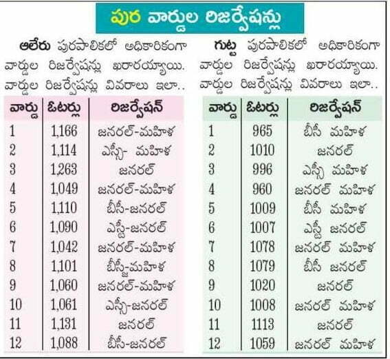
Alair Municipality elections 2020 Ward wise Reservation List
After careful examination of the matter and in supersession of orders issued vide reference, the Government hereby decide to issue final notification of division of Alair Municipality into Twelve (12) wards. The following Notification will be published in an Extra-Ordinary Issue of the Telangana Gazette:
In exercise of the powers conferred by sub-section (1) of section 6 of the Telangana Municipalities Act No. 11 of 2019 read with Telangana Municipalities (Division of Municipalities into wards) Rules 2019, issued in G.O.Ms.No.78, Municipal Administration and Urban Development (MA) Department, Dated 29.06.2019, the Governor of Telangana hereby notify the division of Alair Municipality into Twelve (12) wards as described in the Annexure appended to the notification with immediate effect.
ALAIR MUNICPALITY : YADADRI BHONGIR DISTRICT DESCREIPTION OF WARD BOUNDARIES
WARD No. 1
Starts from Municipal Boundary Near Donthiri Somireddy Function Hall
NORTH Runs towards east side along the municipal boundary and open fields up to municipal boundary.
Starts form Municipal boundary and runs towards south side along the EAST road and open fields up to Railway Track
Starts form Railway Track at South East corner and runs towards west
SOUTH the railway track up to near H.No. 1-100 side along
Starts form H No. 1-100 at Kolanpak Road and runs to wards north side WEST along the road from the town up to Municipal Boundary Near Donthiri Somireddy Function Hall.
WARD No. 2
Starts from municipal boundary of ward No. 1 and runs towards east side NORTH Vagu. up to Durgamma Temple at Alair
Starts form Durgamma Temple at Aler vagu and runs towards
EAST Government Hospital at Jeedikal Road and runs towards south side along with the Jeedikal Road up to Ramalayam Temple.
Starts form Ramalayam temple at jeedikal road and runs towards west SOUTH side Ramasamudram Village along with Municpal Boundary and open fields up to Muncipal Boundary at South west corner.
Starts form municipal boundary at south west corner and runs towards west side along with open fields and take turn towards east side and runs along with open filed and take turn towards north side and runs WEST along with Alair Wagu up to Durgamma Temple up to Railway Track at take turn towards south side and along the railway track and take turn towards north side and runs along with open fields and H.No. 1-300 and runs up to municipal boundary of ward No. 1
WARD No. 3
Starts from H.No. 15-52 and runs towards east side along the Railway
NORTH Track up to H.No. 15-1 Near Durgamma Temple.
Starts from H.No. 15-1 and runs towards south side along with the Alair EAST Wagu and open fields up to Ramasamudram Village boundary.
Starts from Ramasamudram Village boundary and runs towards west
SOUTH side along with open fields up to south west corner.
Starts from south west corner and runs towards open fields and road through Katamaiah Nagar up to H.No. 14-65/1 and take turn towards WEST
south side and runs upto H No. 14-121 and take turn towards north side and runs upto H.No. 15-52
WARD No. 4
Starts from Railway Track Near H.No. 13-4 and runs towards railway
NORTH track up to north east corner. Starts from Railway Track north east corner and runs towards south side
EAST up to Opp. H.No. 14-121 and take turn towards north side and runs upto
Opp. H.No. 14-65/1 and take turn towards south side and runs along with existing road through H.No. 13-31 and runs along with open fields up to municipal boundary at east south corner.
Starts from municipal boundary east south corner and runs towards west side along with municipal boundary up to south west corner.
Starts from municipal boundary at south west corner and runs towards north side along with open fields and kutch road open fields up to H.No. 13-215 and take turn and runs along with existing road up to railway track at H.No. 13-4
WARD No. 5
Starts from H.No. 1 1-33 at railway track and runs towards east side
NORTH up to H.No. 12-68 along with railway track
Starts from Railway Track H.No. 12-68 and runs towards south side up EAST to H.No. 12-222 and take turn and runs along the road and open fields up to municipal boundary
Starts from municipal boundary at east south corner and runs towards SOUTH west side along with municipal boundary up to south west corner.
WEST Starts open to BT along and from municipal boundary at south west corner and runs along with fields and kutch road and take turn towards south side and runs up H.No. 10-128/2 and take turn towards north side and runs along with road up to H.No. 11-44 and take turn towards south side and runs with the NH 163 up to ZP School and take turn towards north side runs upto railway track at H.No. 11-33
WARD No. 6
Starts from Bahadurpet Road at H.No. 11-31 and runs towards east side NORTH along with Pwd road up to H.No 11-62
Starts from H.No. 11-62 and runs towards south side along municipal EAST boundary at Bahadurpet Village. road and open fields up to municipal
SOUTHside along with open fields and kutcha roads up to municipal oundary at south west corner.
Starts from municipal boundary at south west corner and runs towards north side along with open fields and take turn towards east side and
WEST runs along with open fields up to Bahadurpet Road at H.No. 10-182/5 and take turn towards north side and runs along with BT road of Bahadurpeta up to H.No. 10-128/2
WARD No. 7
NORTH Starts from PWD Hyderabad Road at municipal boundary and runs towards east side along with NH 163 and take turn east side up to railway track and take turn and runs along the railway track up to railway gate.
EAST Starts from Railway Gate and runs towards manthapuri Village road along with BT road up to Budiga Jangala colony i.e. 10-182/5
SOUTH Starts from budiga Jangala Colony at H.No. 10-182/5 and runs towards west side along with open fields up to municipal boundary at south west corner
WEST Starts from municipal boundary at south west corner and runs towards north side along with fields up to PWD Hyderabad road
WARD No. 8
NORTH Starts from municipal boundary at north west corner and runs towards east side along with open fields and municipal boundary up to north east corner
EAST Starts from north east corner and runs towards south side along with open fields and kutcha road up to Raghunathapuram road and take turn runs along with BT road of Raghunathapuram and Pochamma Temple up to H.No. 9-296 and take turn towards south side and runs up to H.no.9-260 and take turn towards north side and runs up to 9-123 and take turn towards south side and runs up to NH 0163
SOUTH Starts from NH 163 Hyderabad road runs towards west side along with NH road up to municipal boundary through Reddygudem.
WESt Starts from municipal boundary at NH 163 Hyderabad road and runs toward north side along with open fields and municipal boundary up to north west corner
WARD No. 9
SOUTH Starts from H.No. 9-296 and runs towards east side along with pochamma temple road and take turn towards north side and runs along the road and again take turn east side and runs up to H.No.8-180.
Starts from H.No.8-180 and runs towards south side along with existing road up to H.No. 9-1
Starts from H.No. 9-1 at Railwaygate and runs towards west side along the railway track H.No.9-100
WEST Starts from Railway track at H.No. 9-100 and runs towards north side and runs up to H.No 9-123 and take turn towards south side and runs along with road up to H.No. 9-260 and take turn towards north side and runs up to Pochamma temple road at H.No. 9-296
WARD No. 10
NORTH Starts from municipal boundary at north west corner runs towards east side along open fields and municipal boundary up to north east corner
EAST Starts from north east corner and runs towards south side along with kutcha road and open fields and take turn towards south side and runs up to H.No 8-167/7and take turn towards east side and along with exist road up to H.no.4-113
SOUTH Starts from H.no.4-113 and runs towards west side along with road and take turn towards south side and runs along with existing road up to Pochamma temple road and take turn towards west side along with Pochamma temple road and Raghunathpuram road up to south west corner.
WEST Starts from south west corner at Raghunathpuram road and runs towards north side along with kutcha road and open fielded up to municipal boundary at north west corner Starts from municipal boundary
WARD No. 11
NORTH Starts from Opp. H.No.3-132/1 and runs along the road up to Opp. H.N0.3-127
EAST Starts from Opp. H.No.3-127 and runs towards south side along with existing road with small curves up to H.No 2-3 and take turn at Kolanpak road runs up to Railway Track
Starts from Railway track near h.no.2-3 and runs towards west side
SOUTH along with Railway Track up to railway gate near H.No. 6-60.
Starts from Railway Gate Near H.No. 6-60 and runs towards north side WEST along with existing road with H No. 4-112 and small curves up to Opp. H. No. 3-132/1
WARD No. 12
Starts from north west corner of municipal boundary and runs towards
NORTH east side along with open fields and municipal boundary up to north east corner.
Starts from north east corner of municipal boundary near Donthiri
EAST Somireddy Function Hall and runs towards south side along with open fields and existing road up to Railway Track Near H.No. 2-1 .
Starts from Railway track near H.No.2-1 and runs towards west side
SOUTH along with railway track up to south west corner near h.no.2-3.
Starts from Railway track Near H.No. 2-3 and runs towards north side with small curves up to H.No. 3-127 and take turn towards east side and WEST runs along the road and fields and again take turn towards north side runs along with open fields up to municipal boundary at north west corner.