Kamareddy Municipality, Kamareddy District – Division of Kamareddy Municipality into forty nine (49) wards Final Notification Director of Municipal Administration, Telangana, Hyderabad has stated that, the Commissioner, Kamareddy Municipality has submitted a proposal for division of Kamareddy Municipality into forty nine (49) wards after following the due procedure as prescribed in and requested to issue final notification.
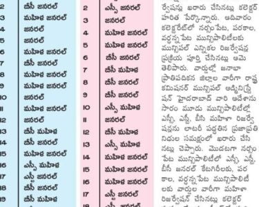
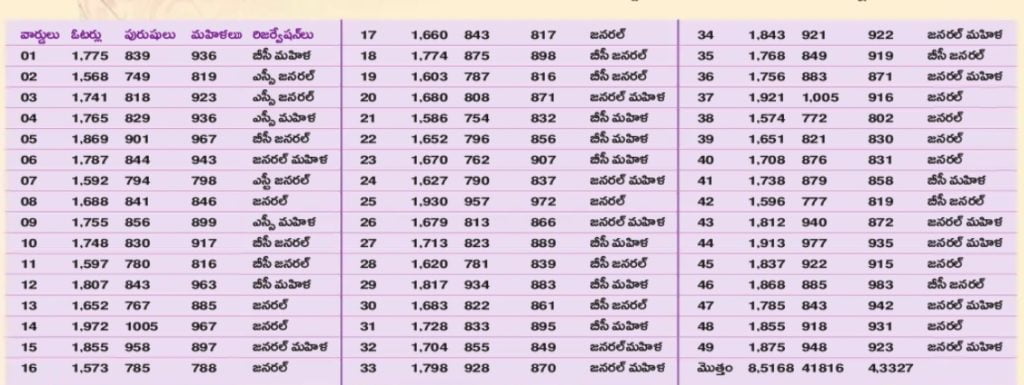
49 wards of Kamareddy Municipality Reservation List
After careful examination of the matter and in supersession of orders issued vide reference 2nd read above, Government herby decide to issue final notification of division of Kamareddy Municipality into forty nine (49) wards.
The following Notification will be published in an Extra-Ordinary Issue of the Telangana Gazette NOTIFICATION
In exercise of the powers conferred by sub-section (1) of section 6 of the Telangana Municipalities Act No. 11 of 2019 read with Telangana Municipalities (Division of Municipalities into wards) Rules 2019, issued in G.O.Ms.No.78, Municipal Administration and Urban Development (MA) Department, Dated 29.06.2019, the Governor of Telangana hereby notify the division of Kamareddy Municipality into forty nine (49) wards as described in the Annexure appended to the notification with immediate effect.
ANNEXURE TO G.O. Ms. No. 324, MA & UD (MA.” Department, dated 17-12-2019 KAMAREDDY MUNICIPALITY
DESCREIPTION OF WARD BOUNDARIES
Kamareddy Municipality WARD NO. 1
NORTH Starts in sy.no.96/2 of Tekriyal village runs along the mpl./village boundary and ends at sy.No.105 of Adloor village.
EAST Starts in Sy.105 runs along the pathway and ends at Sy.No.23 of Adloor village at NH.44road.
SOUTH Starts from Sy.No.23 of Adloor village runs along the NH-44 road and ends Sy.No.134 of llchipur.
WEST Starts from Sy.No.134 of llchipur village ends at Sy.No.96/2 of Tekriyal village at NH-44.
Kamareddy Municipality WARD NO.2
NORTH Starts in Sy.No.106 of Adloor village runs along the municipal boundary and ends at Sy.No.82/20 of Rameshrarpally village.
EAST Starts from Sy.No.82/20 Rameshwarpally village runs along the
Municipal boundary ends at Sy.No.39 junction of Sircilla Road and NH-
SOUTH Starts at Junction runs along the National Highway ends at Sy.No.612 of adloor village at NH-44.
WEST Starts in Sy.No.612 of Adloor village at NH-44 runs along the pathway ends at Sy.No. 106 Adloor village.
Kamareddy Municipality WARD NO.3
NORTH Starts from 3-8-51 runs towards east upto NH-44 towards Municipal boundary at Sy.No.197/1
EAST Starts at Sy.No.197/1 end run towards south end at NH-44 i.e Municipal Boundary at Sy.No.16.
SOUTH Starts fror Municipal Boundary at Sy.No. 16.and proceed towards east end upto 3-6-93 and turn left ends at 3-6-31.
WEST Starts from 3-6-31 proceeds along the Harijana wada road ends at H.N0 3-8-51.
Kamareddy Municipality WARD NO.4
NORTH Starts from H.No.3-6-42 proceed towards H.No 3-6-36 east directions turns North at 3-6-91 and ends at NH-44 i.e Municipal boundary Sy.No.15.
EAST Starts from NH-44 proceed towards straight end at NH-44 at Sy.N0.286/1.
SOUTH Starts from NH-44 proceed to west ends at 4-4-120
WEST Starts from H.No.4-4-120 and turn end upto 3-6-42.
Kamareddy Municipality WARD NO.5
NORTH Starts at H.No.4-5-274 proceed straight end and Municipal limits Sy.No. 14.
EAST Starts at Sy.No.14 proceed along the Municipal Boundaries and upto Sy.N0.173 .
SOUTH Starts at Sy.No.173 Proceed straight upto Sy.No.278.
WEST Starts at Sy.No.278 proceed towards north at H.No.4-5-200 turn left and end upto 4-5-274.
Kamareddy Municipality WARD NO.6
NORTH Starts at Sy.No.38 Sarampally village runs along the village boudary ends at Sy.No.47 of Sarampally village
EAST Starts at Sy.No.47 of Sarampally village runs along the Municipal boundary ends at Sy.No.145 of Patharajampet village.
SOUTH Starts at Sy.No. 145 of Patharajampet village runs along the Municipal boundary ends at Sy.No.206/1 of Patharajampet village.
WEST Starts at Sy.No.206/1 of Patharajampet village runs along the
Municipal boundary and ends at Sy.No.38 of Sarampally village
Kamareddy Municipality WARD NO. 7
NORTH Starts at H.No.5-2-159 near old NH7 runs towards east ends at H.No.52-25 of Vikas nagar Near Railway Track.
EAST Starts at H.No.5-2-25 of Vikas nagar runs alomg the railway track and ends at Sy.No.528 of kamareddy village.
SOUTH Starts at Sy.No.528 of kamareddy village runs along the kamaredyy village boundary and ends at Sy.No.695/1 Near old NH-7
WEST Starts at Sy.No.695/1 of kamareddy village runs towards North along old NHH-7 road.
Kamareddy Municipality WARD NO.8
NORTH Starts from Jeevadhan School, Nizam Sagar Road i.e North west corner of ward boundary move towards East direction through nizam sagar roads end at H.no.5-3-121 of Amar sai engineering at Nizam sagar chowrastha i.e, North East corner of ward boundary.
EAST It starts from above point i.e, north east corner of ward boundary and moves towards south direction through old NH-7 road and ends at ESSAR petrol bunk point at GR colony i.e, culvert i.e, south east corner of ward boundary.
SOUTH It starts from above point i.e, south east corner of the ward boundary and move towards west direction and ends at Sy.No.711 of Sarampally village at pedda cheruvu bound i.e, south west corner of ward boundary.
WEST It starts from above point i.e, south west corner of the ward boundary moves towards the north direction through the peddda cheruvu bound and ends at Jeevadhan School at Nizam sagar road i.e, north west corner of the ward boundary.
Kamareddy Municipality WARD NO.9
NORTH Starts from H.No.8-1 runs along the Nizamsagar Chourasta and end @8-1
EAST Starts from 8-1 runs along the road and via at Gangamma gudi of pedda cheravu and endsat Sy.No. 310 of Lingapur
SOUTH Starts from Sy.No.310 of Lingapur(V) runs along the Municipal boundaries and ends at Sy.No.328 of Lingapur
WEST Starts from Sy.No.328 of Lingapur(V) runs along the Sy.No’s and end at 10-1 of Lingapur
Kamareddy Municipality WARD NO. 10
NORTH Starts at H.No.3-145/2 Alluri sitarama Raju Statue,Old Devunpally Village runs along the Nizamsagar road and ends and at H.no.16-184 of Devunpally Village.
EAST Starts at H.no.16-184 of Devunpally Village runs along village boundary of Devunpally and ends at H.no.16-175 of Devunpally village.
SOUTH Starts at H.no. 16-175 Devunpally Village runs along the village boundary od Devunpally and ends at Sy.No.121.
WEST Starts in Sy.No.121 and ends at H.no.3-145/2
Kamareddy Municipality WARD NO.II
NORTH Starts at Sy.No.413/2 of Lingapur village runs along the Nizam sagar road and ends at Sy.No.9 of Lingapur village near Dhobi Ghat.
EAST Starts at Sy.No.9 of Lingapur village near Dhobi Ghat runs along the village boundary ens at Gandhi statue of Lingapur village.
SOUTH Starts at Gandhi statue of Lingapur village runs along with CC road and ends at Sy.No.328 of Lingapur village.
WEST Starts at Sy.No.328 of Lingapur village runs along the Municipal boundary ends at Sy.No.413/2 of Lingapur village.
Kamareddy Municipality WARD NO. 12
NORTH Starts at Sy.No.439 of Devunpally Village runs towards east and ends at H.no.6-66
EAST Starts at H.no.6-66 runs towards south and ends at H.no.15-69 of Devunpally Village at Nizam sagar road.
SOUTH Starts at H.no.15-69 of Devunpally Village runs towards west along the Nizam sagar Road and ends at Sy.No.431.
WEST Starts at Sy.No.431 runs along the Municipal Boundary and ends at Sy.No.439 of Devunpally Village.
Kamareddy Municipality WARD NO. 13
NORTH Starts at Sy.No.229 of Tekriyal village runs along the Municipal boundary and ends at Sy.No.93 of Tekriyal village
EAST Starts at Sy.No.93 of Tekriyal village runs along the old NH-7 road and ends at Sy.No. 145 of Tekriyal village
SOUTH Starts at Sy.No. 145 of Tekriyal village runs along the village boundary of tekriyal ends at Sy.No.206 of Tekriyal village.
WEST Starts at Sy.No.206 of Tekriyal village runs along the Municipal boundary and ends at Sy.No.229 of Tekriyal village
Kamareddy Municipality WARD NO. 14
NORTH Starts at Sy.No.188 of Tekriyal village runs towards east and ends at Sy.No.131 of tekriyal village near old NH-7.
EAST Starts at Sy.No.131 of Tekriyal village near old NH-7 and runs towards south along old NH-7 and ends at saraswathi shishu madhir,at NH-7 road.
SOUTH Starts at saraswathi shishu madhir, at NH-7 road runs towards west and ends end H.no.5-6-297.
WEST Starts at H.no.5-6-297 runs towards north and endfs at Sy.No. 188 of Tekriyal village.
Kamareddy Municipality WARD NO. 15
NORTH Starts from NH-44 at Sy.No.133 of Elchipur i.e. North west corner of the ward boundary moves towards the East direction through NH-44 ends at Sy.No 109 of Elchipur Village i.e. North – East corner of the ward boundary
EAST Its starts from the above point i.e. North – East corner of the ward boundary moves towards the south direction through Sy.No.120, 117 of Elchipur and Sy.No.801 ,802 of kamareddy andrun along the chandi ashraman road and ends at H.No.5-8-906.
SOUTH Its starts from the above point i.e. South – East corner of the ward boundary moves towards the west direction through Church Road ends at H.No 5-8-917 i.e. South-west corner of the ward boundary
WEST Its starts from the above point i.e. South – West corner of the ward boundary moves towards the North direction through Old NH-7 Road ends at Sy.No 133 of Elchipur at NH-44 Road i.e. North-West corner of the ward boundary
Kamareddy Municipality WARD NO. 16
NORTH Starts from NH-44 at Sy.No 110 of Elchipur Village i.e. North west corner of the ward boundary moves towards the East direction through NH-44 ends at Sy.No 113 of Elchpur Villege i.e. North – East corner of the ward boundary.
EAST Its starts from the above point i.e. North – East corner of the ward boundary moves towards the south direction through 5-Temples road and turns towards East at H.No 5-8-645/1 then runs along railway gate road then turns towards South at Ambedkar statue and ends i.e,SouthEast corner of the ward boundary.
SOUTH Its starts from the above point i.e. South – East corner of the ward boundary moves towards the west direction through Excise office road and at H.No 5-8-904 i.e. South-west corner of the ward boundary.
WEST Its starts from the above point i.e. South – West corner of the ward boundary moves towards the North direction through Water tank road then towards Hostel road H.No 5-8-845 then turns towards PR Office road at H.No 5-8-855 then ends at Sy.No 110 at NH-44 i.e. North-West corner of the ward boundary.
Kamareddy Municipality WARD NO. 17
NORTH Starts from Sy.No 113 of Elichpur Village i.e. North west corner of the ward boundary moves towards the East direction through NH-44 and ends at Sy.No 619 of Adloor Village i.e. North – East corner of the ward boundary
EAST Its starts from the above point i.e. North – East corner of the ward boundary moves towards the south direction through the railway track ends at H.No 5-8-344 of Gangadhar i.e. South-East corner of the ward boundary.
SOUTH Its starts from the above point i.e. South – East corner of the ward boundary moves towards the west direction through the culvert and ends at H.No 5-8-345/1 (dismantled house of Eshwaramma) i.e. Southwest corner of the ward boundary.
WEST Its starts from the above point i.e. South – West corner of the ward boundary moves towards the North direction and turns towards west at
H.No 5-8-343 and runs along church road then turns towards North at
H.No 5-8-488 then runs along the Excise office road and turns towards
East at H.No 5-8-593 and runs along PT Laxman road and turns towards North at H.No 5-8-411 and runs along vasavi school road and turns west at Ambedkar statue and runs along Railway gate road and turns towards North at H.No 5-8-646 and runs along the 5-temples road and ends at NH-44 at Sy.No 113 of Elichpur i.e. North-West corner of the ward boundary.
Kamareddy Municipality WARD NO. 18
NORTH Starts from NH-44 Sy.No.610 and runs towards the NH-44 and ends at Sy.No.139.
EAST Starts from Sy.No.139 runs along the 0m Shanti Road and ends at H.No.1-4-599/2.
SOUTH Starts from H.No.1-4-599/2 runs along the kareem milk center road and ends at H.No.1-4-452.
WEST Starts from H.No.1-4-452continue on Adloor road and ends at Sy.N0.610 at NH-44.
Kamareddy Municipality WARD NO.19
NORTH Starts from Sy.No.130 and runs along the NH-44 ends at Rama Reddy Road sy. N0519.
EAST Starts from Sy. No.519 at Rama Reddy Road and runs towards at Rama Reddy Road end at Raja Nagar.
SOUTH Starts from Raja Nagar colony and runs towards sailani baba colony road and ends at H.No.1-4-590/4.
WEST Starts from H.No.1-4-590/4 runs towards om Shanthi road and ends at Sy.No.130.
Kamareddy Municipality WARD NO.20
NORTH Starts at Ramareddy beginning Sy.No.514 runs along the road upto ambedkar statue.
EAST Starts at ambedkar statue runs along the road ends at H.No.1-14-20.
SOUTH Started from H.No.1-14-20 runs along the road upto ramareddy road and ends at the same place.
WEST Starts at ramareddy Road Runs along the chourasta and ends at the same place at Sy.No.514
Kamareddy Municipality WARD NO.21
NORTH Starts at Ramareddy road runs along the NH-44 ends at Sy.No.569 of Adloor village.
EAST Starts at Sy.No.569 of Adloor village runs along the NH-44 ends at Sy.No.191 part.
SOUTH Starts from Sy.No.191 part runs along the west directions passing through the BT road up to Ramareddy road.
WEST Starts from runs along the Ramareddy road ends at NH-44.
Kamareddy Municipality WARD NO.22
NORTH Starts at H.No.1-15/440/1 run along the BT road ends at Sy.No.198 of Rameshwarpally(V) at NH-44.
EAST Starts at Sy No. 198 of Rameshwarpally at NH-44 runs along the ends at Sy.No.185 of Rameshwarpally.
SOUTH Starts from Sy.No.185 of Rameshwarpally runs along tha Kachha road and ends at H.No.1-15-406.
WEST Starts from H.No. 1-15-406 runs along the BT road and end at H.No.6-63.
Kamareddy Municipality NO.23
NORTH Starts from H.No.1-15-402 and runs along with vambey colony road ends at H.No.1-15-251 and ends at Sy.No.180.
EAST Starts from Sy.N.180 and runs along the NH-44 at Sy.No.182.
SOUTH Starts from Sy.No.182 and runs towards ZPHS School road ends at Sy.No.55.
WEST Starts at Sy.No.55 and runs along the 80-00 Feet road and ends at
H.No.1-15-402.
Kamareddy Municipality WARD NO.24
NORTH Starts from Ramareddy Road and runs along vambey colony road ends at H.No.1-13-162.
EAST Starts from H.No.1-13-162 and runs towards ZPHS School turns at
H.No.1-13-352 and ends at Grave Yard.
SOUTH Starts from grave yard and runs along the Grave Yard road ends at H.NO.1-5-413/2.
WEST Starts from H.NO.I -5-413/2 and runs towards rama Reddy road and ends at same place.
Kamareddy Municipality WARD NO.25
NORTH Starts from H.NO.I -5-389 and runs along the siricilla road and ends at Sy.No.172.
EAST Starts from Sy.No. 172 runs along the ward boundary ends at Sy.No. 191.
SOUTH Starts from Sy.No.191 and passess along the indra nagar grave yard and turns at H.No.3-9-115 and ends at H.NO.3-9-52.
WEST Starts from H.NO.3-9-52 and passess along the siricilla road and ramareddy road and turns north at H.No.1-5-446 ends at H.No.1-5-389.
Kamareddy Municipality WARD NO.26
NORTH Starts from H.No.3-1-189 runs along siricilla road upto H.No.3-1-205.
EAST Starts from H.No.3-1-205 straight upto 3-9-5 and turns towards east proceed H.No.3-9-36 and turn towards south ends at 3-9-10.
SOUTH Starts from 3-9-10 proceed towards west take turn ends at H.No.3-2-7.
WEST Starts from H.No.3-2-7 run along the weekly market road ends upto 31-189.
Kamareddy Municipality WARD NO.27
NORTH Starts from H.No.3-2-31 run towards east ends at Girls high School.
EAST Starts from Girls high School and proceed then towards south end upto 3-5-67
SOUTH Starts from 3-5-67 and proceed to west and ends at H.No.3-4-10
WEST Starts from 3-4-10 proceed to north and ends at H.No.3-2-31.
Kamareddy Municipality WARD NO.28
NORTH Starts from H.No.4-2-33 proceed towards east along pedda bazaar road and ends at 4-4-92
EAST Starts from 4-4-92 proceed towards south ends at 4-4-81
SOUTH Starts from 4-4-81 to proceed straight along the Bhavani road ends upto 4-2-6
WEST Starts from H.No.4-2-6 proceed towards end at 4-2-33.
Kamareddy Municipality WARD NO.29
NORTH Starts at H.No.4-6-88 proceed towards east end upto H.No.4-6-67/2.
EAST Starts at H.No.4-6-67/2 proceed towards south end upto railway track at sy.No.138.
SOUTH Starts from railway line take turn ends straight and proceed towards south ends at railway line at Sy.No.611 of kamareddy.
WEST Starts from Railway track end proceed straight take left at H.No.48-38 and end at 4-6-88.
Kamareddy Municipality WARD NO.30
NORTH Starts at 4-9-59 proceeds towards east end at 4-8-10.
EAST Starts from 4-8-10 proceed towards south turn at H.No.4-7-68 proceed straight ends railway track.
SOUTH Starts from Railway line the proceed along the railway track upto H.no.410-5/1
WEST Starts from H.no. 4-10-5/1 at railway track Proceed towards north ends at 4-9-59.
Kamareddy Municipality NO.31
NORTH Starts from H.No.4-11-118 proceed along the Bhavani road end upto4-11-51
EAST Starts from H.No.4-11-51 proceed straight along the south ends at H.No.4-10-17.
SOUTH Starts from H.No.4-10-17 proceed straight upto railway track H.No.4-10-101/1.
WEST Starts from H.No.4-10-101 / 1 proceed along the railway line ends of 4-11-118
Kamareddy Municipality WARD NO.32
NORTH Starts from H.No.5-5-42(Thirumala ice cream parlour) at old NH-7 road i.e, north-west corner of the moves towards the east direction through chitra flexy road ends at H.No.5-5-52 i.e, north-east corner of the ward boundary.
EAST It starts from above point i.e, north-east corner of the ward boundary moves towards the south direction through Reddy mess Road H.No.5-5-100 and runs along the Municipal office road and turns soth at H.No.5-4-62 then runs along the railway track and ends at h.No.5-2-24 i.e, south-east corner of the ward boundary.
SOUTH It starts from above point i.e, south-east corner of the ward boundary moves towards the west direction through NDCC Bank road ends at R&B Guest House at old NH-7 road i.e, as south-west corner of the ward boundary.
WEST It starts from above point i.e, north-west corner of the ward boundary moves towards the north direction through 01s NH-7 road ends at H.No.5-5-42 i.e, north-west corner of the boundary.
Kamareddy Municipality WARD NO.33
NORTH Starts from old sai baba temple X-road i.e. open plot beside H.No.5-4459 i.e, North west corner of the ward boundary moves towards the East direction through sai baba temple road ends at H.No.5-3-246 i.e. North – East corner of the ward boundary.
EAST Its starts from the above point i.e. North – East corner of the ward boundary moves towards the south direction through old NH-7 road (Honey bakery) ends at H.No.5-3-213 at Nizam Sagar X-road i.e. South-East corner of the ward boundary.
SOUTH Its starts from the above point i.e. South – East corner of the ward boundary moves towards the west direction through Nizam Sagar road and ends at open plot beside H.No.5-3-512 i.e. South-west corner of the ward bounda
WEST Its starts from the above point i.e. South – West corner of the ward boundary moves towards the North direction through Janma bhoomi road and ends at open plot beside H.No.5-3-459 i.e. North-West corner of the ward boundary
Kamareddy Municipality WARD NO.34
NORTH Starts at H.No.13-99 runs towards east and ends at old saibaba Temple chourasta.
EAST Starts at old sai baba temple chourasta runs towards south and ends at janmabhoomi chourasta H.No.5-3-537/4
SOUTH Starts at janmabhoomi chourasta runs towards west along the Nizamsagar road and ends at Devunipally chourasta.
WEST Starts at Devunipally chourasta runs towards north and ends at H.No.13-99.
Kamareddy Municipality NO.35
NORTH Starts at Sy.No.179 of Devunpally Village runs towards east and ends at Starts at Sy.No.208 of Devunpally Village.
EAST Starts at Sy.No.208 and ends at H.no.14-10
SOUTH Starts at H.no.14-10 and ends at Sy.no.222 of Devunpally Village.
WEST Starts at Sy.no.222 of Devunpally Village and ends at Sy.no.179 of Devunpally Village.
Kamareddy Municipality WARD NO.36
NORTH Starts at H.no.5-6-417 towards east and ends at TV Station at Old NH7 Road.
EAST Starts at TV Station runs towards south and ends at H.no.5-6-656/A
SOUTH Starts at H.No.5-6-656/A runs towards west and ends Old sai baba temple chowrastha at open plot beside H.no.5-3-726.
WEST Starts at open plot beside H.No.5-3-726 runs along the Janma bhoomi road and ends at H.No.5-6-417.
Kamareddy Municipality WARD NO.37
NORTH Starts at TV Tower H.No.5-6-518 at old Nh-7 and ends at New stand Chourasta.
EAST Starts at new bus stand chourasta runs along old NH-7 and ends at H.N0.5-3-621.
SOUTH Starts at H.No.5-3-621 runs towards west ends at saibaba Temple chourasta H.No.5-3-781
WEST Starts at H.No.5-3-781 01s sai baba temple chourasta runs towards north and ends at Tv tower.
Kamareddy Municipality WARD NO.38
NORTH Starts from H.No.5-8-14 at NH-7 Road i.e. North west corner of the ward boundary moves towards the East direction through Raja Xerox Road and Bassera lodge road ends at H.no.5-7-163 i.e. North – East corner of the ward boundary
EAST Its starts from the above point i.e. North – East corner of the ward boundary moves towards the south direction and ends at H.No 5-7-337
i.e. South-East corner of the ward boundary .
SOUTH Its starts from the above point i.e. South – East corner of the ward boundary moves towards the west direction through Priya Talkies road ends at H.No.5-8-1 i.e. South-west corner of the ward boundary
WEST Its starts from the above point i.e. South – West corner of the ward boundary moves towards the North direction through old NH-7 road ends at H.No.5-8-14 at NH-7 road ends at North-West corner of the ward boundary
Kamareddy Municipality WARD NO.39
NORTH Starts from Rukumini kunta school road i.e. North west corner of the ward boundary moves towards the East direction ends at H.No.5-772/6 i.e. North – East corner of the ward boundary
EAST Its starts from the above point i.e. North – East corner of the ward boundary moves towards the south direction through railway track ends at H.No.5-5-236 i.e. South-East corner of the ward boundary
SOUTH Its starts from the above point i.e. South – East corner of the ward boundary moves towards the west direction through Municipal office road ends at H.No.5-5-152 i.e. South-west corner of the ward boundary
WEST Its starts from the above point i.e. South – West corner of the ward boundary moves towards the North direction through Reddy Mess road and turns west at H.No.5-5-22 and runs along chitra flexi road then turns northof H.No.5-5-18 then turns east at H.No.5-5-39 and turns north at H.No.5-7-25 then turns towards east at H.No.5-7-98 and ends at H.No.5-7-72/6 i.e. North-West corner of the ward boundary.
Kamareddy Municipality NO.40
NORTH Starts from NH-7 road at H.No.5-8-64 i.e. North west corner of the ward boundary moves towards the East direction through Chruch road ends at H.No.5-8-342 i.e. North – East corner of the ward boundary
EAST Its starts from the above point i.e. North – East corner of the ward boundary moves towards the south direction through Parshiramulu Kalyana Mandapam back side road ends at H.No.5-8-278 i.e. SouthEast corner of the ward boundary
SOUTH Its starts from the above point i.e. South – East corner of the ward boundary moves towards the west direction through Baseera Lodge road and Raja xerox road ends at H.No.5-8-30 i.e. South-west corner of the ward boundary
WEST Its starts from the above point i.e. South – West corner of the ward boundary moves towards the North direction through old NH-7 road ends at H.No.5-8-64 at Church road i.e. North-West corner of the ward boundary
Kamareddy Municipality WARD NO.41
NORTH Starts from H.No.1-4-432 and runs along the karrem milk center road and ends at H.No.1-12-112.
EAST Starts from H.No.1-12-112 and road and ends at H.No.1-12-120.
SOUTH Starts from H.No.1-12-120 and runs towards west and ends at H.No.14-387.
WEST Starts from H.No.1-4-387 and ends at Adloor road H.No.1-4-432…
Kamareddy Municipality WARD NO.42
NORTH Starts from H.No.1-12-160 and runs along Masjid road.
EAST Starts from Masjid road runs along the Bhupatramma road.
SOUTH Starts from Bhupatramma road and turns south and ends at H.No.112-243.
WEST Starts from H.No.1-12-243 and runs along Bhathukamma kunta road and ends at H.No.1-12-160.
Kamareddy Municipality WARD NO.43
NORTH Starts from siricilla road H.No.1-5-1 and runs towards siricilla road.
EAST Starts from H.No.1-5-28 and turns towards Bhuputhramma kalyana mandapam road.
SOUTH Starts from H.No.1-5-62/1 and turns towards R R Hospital road.
WEST Starts from H.No.1-5-88 and run towards R R hospital road and towards east and join rama Reddy road and turn towards 1-5-290.
Kamareddy Municipality WARD NO.44
NORTH Starts from H.No.1-11-78 and runs along with siricilla road and ends at H.N0.1-6-63/1.
EAST Starts from H.No.1-6-63/1 and runs along the weakly market road and ends at opposite to Munnurukapu Sangham.
SOUTH Starts from Munnurukapu Sangham runs towards Ganji road ends at H.No.1-9-1.
WEST Starts from H.No.1-9-1 run towards station road and ends at H.No.1-1178.
Kamareddy Municipality WARD NO.45
NORTH Starts from H.No.2-3-64 runs towards east along subash road ends upto H.No.1-6-174
EAST Starts from H.No.1-6-174 runs towards south runs ends at H.No.2-8-
SOUTH Starts from H.No.2-8-44 runs towards west along the peddabazar road ends at H.No.2-8-7.
WEST Starts from H.No.2-8-7 runs along the straight road upto subash road ends upto H.No.2-3-64.
Kamareddy Municipality WARD NO.46
NORTH Starts from H.No.2-2-1 runs towards east along the chota kasab gally ends at H.N0.2-2-59.
EAST Starts from H.No.2-2-59 runs towards south along gadi road ends at H.No.2-7-50
SOUTH Starts from H.No.2-7-50 runs towards west along the peddabazar road ends at H.no.2-7-25.
WEST Starts from H.No.2-7-25 runs towards north along the bharath road ends upto 2-2-1.
Kamareddy Municipality WARD NO.47
NORTH Starts from railway track on north western the subash road and ends at Raja oil beginning H.No.2-3-45
EAST Starts from H.No.2-3-45, subash road runs along the Shivaji road, at H.No.2-4-86 runs along the road of chota kasab gally and turn at 2-5-3 runs straight upto end H.No.2-6-46 ends at 4-1-55 of Bhavani road start.
SOUTH Starts H.No.4-1-55 runs along the bhavani road and ends at H.No.2-177 at Pedda bazaar.
WEST Starts from H.No.2-1-77 runs along with rail track and end forest office.
Kamareddy Municipality WARD NO.48
NORTH Starts fromH.No.1-4-401 / 1 and runs along PMH road and ends atH.N0.1-12-1
EAST Starts from at H.No.1-2-1 and runs along Bathukamma kunta road and ends at H.No.1-4-31 / 1 .
SOUTH Starts from H.No.1-4-31 / 1 and runs along osmanpura road and runs along the Adloor road.
WEST Starts from 1-1-1 and runs along the Adloor road and ends at 1-4401 / 1 .
Kamareddy Municipality WARD NO.49
NORTH Starts from H.No. 1-3-181 runs towards Shanti talkies road runs towards west at H.No. 1-3-144
EAST Starts from H.No. 1-3-144 and run towards Dharmashala road H.No.1 -258.
SOUTH Starts from Dharmashala H.No.1-2-58 and run towards siricilla road H.No.1-2-1.
WEST Starts from H.No.1-2-1 and ends at H.No.1-3-181.