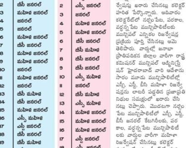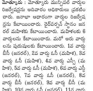
Turkayamjal Municipality, Ranga Reddy District Division of Turkayamjal Municipality into twenty four (24) wards Final Notification – Orders – Issued.
Director of Municipal Administration, Telangana, Hyderabad has stated that, the Commissioner, Turkayamjal Municipality has submitted a proposal for division of Turkayamjal Municipality into twenty four (24) wards after following the due procedure as prescribed in G.O. 1 st read above and requested to issue final notification.
After careful examination of the matter and in supersession of orders issued vide reference 2nd read above, Government herby decide to issue final notification of division of Turkayamjal Municipality into twenty four (24) wards. The following Notification will be published in an Extra-Ordinary Issue of the Telangana Gazette:
Turkayamjal Municipality NOTIFICATION
In exercise of the powers conferred by sub-section (1 ) of section 6 of the Telangana Municipalities Act No. 11 of 2019 read with Telangana Municipalities (Division of Municipalities into wards) Rules 2019, issued in G.O.Ms.No.78, Municipal Administration and Urban Development (MA) Department, Dated 29.06.2019, the Governor of Telangana hereby notify the division of Turkayamjal Municipality into twenty four (24) wards as described in the Annexure appended to the notification with immediate effect.
TURKAYAMJAL MUNICIPALITY RANGAREDDY DISTRICT Description of Ward boundaries
Turkayamjal Municipality WARD NO:- 1 ( Munuganoor)
Starts at banjar colony x roads moves towards eastern direction follows North:
village boundary ends near sy no 115 of munganoor (koheda shivaru )
It starts near sy no 115 of munganoor ( koheda shivaru )moves towards East:
southern direction ends near sy no 122 of munganoor (koheda shivaru ) It starts near sy no 122 of munganoor (koheda shivaru )moves towards western direction via – Manasa township, Hno 2-3/26,veda vidya nagar X
South: roads takes right upto adarsh nagar follows ramanuja nagar colony boundary and dwaraka nagar colony boundary ends at 4-6/36 ramesh house on torrur main road
It starts ends at 4-6/36 ramesh house on torrur main road moves towards West: northern direction follows main road ends at banjar colony x roads
Turkayamjal Municipality Ward No. 2 (Koheda)
Starts at Culvert near Peddamaberpet & Munganoor Road moves towards North: Eastern direction follows Village Boundary ends at Madira College.
It starts at Madira College moves towards southern direction Follows
East: Gandicheruvu Naksha Road then joins and ends at Sangi Koheda Road It starts at Sangi Koheda Road (Gandicheruvu Naksha Road) moves towards western direction along Vivekananda Nagar , Sama Narayan Reddy House,H.
South: No. 5-65, along OHSR Tank runs all along H. No. 8-1 & 6-8 ends at Abhishek industries via ZPHS school X Road.
It starts at Abhishek industries follows Village boundary moves towards
West: northern direction and ends at Culvert near Peddamaberpet & Munganoor Road .
Turkayamjal Municipality Ward No.3 ( Omerkhanguda & Omerkhan Diara)
Starts at Koheda Gandicheruvu Naksha Road near Rokkam Govardhan Reddy Poultry Farms moves towards Eastern direction follows the sy no 255 North:
border ends at Koheda shivaru
It starts at Koheda shivaru near sanjeev reddy poultry farms runs towards
East: southern direction follows revenue boundary of Ummarkhan Daira (V) and ends at Spinners industry of Sanghi.
It starts at Spinners industry of Sanghi_moves towards western direction Via H. Nos of 3-200, Green Inns Hotel ( ramoji guest house ) joins and South:
follows main road ends at Sanghi – Koheda,- Gandicheruvu Naksha Road
It starts Sanghi – Koheda,- Gandicheruvu Naksha Road on moves towards
Northern direction follows along Reddy Cheruvu katta and ends at sy no 255
West: Koheda Gandicheruvu Naksha Road near Rokkam Govardhan Reddy Poultry Farms
Turkayamjal Municipality Ward No.4 (Koheda)
Starts at H. No. 6-8 (Ramesh Guptha) moves towards eastern direction all along OHSR Water tank, H. No. 5-65, follows Vivekananda Colony layout and
North: ends at manasa nagar, Green Inns Hotel ( ramoji guest house ) on Koheda Ummarkhanguda Daira Road
It starts at manasa nagar ,Green Inns Hotel (ramoji guest house) on
East: Koheda – Ummarkhanguda Daira Road moves towards Southern direction ends at Koheda Shivaru Via H. Nos of 4-10 ,near sanghi spinner main gate . It starts at Koheda Shivaru moves towards western direction ends near South:
jana chaitanya sai bhaskara layout (Stone Quarry).
West :jana chaitanya sai bhaskara layout (Stone Quarry)moves towards direction joins Ring Road ends at H. No. 6-8 (Ramesh Guptha) via le road following H. No’s 3-69,4-34, 4-21, 4-15, 3-117, 3-122.
It starts at northern berrapa temp
Turkayamjal Municipality Ward No. 5 (Koheda)
Starts at ChalmaReddy Land on Koheda- Torrur Road moves towards Eastern North :direction and ends at ZPHS X road of H. No. 1-1.
It starts at ZPHS X road of H. No. 1-1 moves towards Southern Direction East: following H. No’s 1-10, 1-59, 3-122, 3-117 and ends at Stone Quarry via Sai sudha Layout, DonthiGutta Road.
It starts at Stone Quarry moves towards western direction following Village South:boundary ends at Sri Mithra Layout near ORR.
It starts at Sri Mithra Layout near ORR moves towards Northern direction
West: following Village boundary ends at ChalmaReddy Land on Koheda- Torrur Road via Janachaithanya layout and Panthulu bhavi.
Turkayamjal Municipality Ward No.6 (Brahmanpally)
Starts near st pauls school moves eastern direction follows Village boundary upto R & B road takes left follows srimitra layout boundary North:
joins upto R & B koheda road at abishek industry runs all along the koheda road ends at chalma reddy land
It starts at chalma reddy land on koheda road moves towards to southern
East: direction follows the Hnos 2-16 and 2-50 joins jana chaitnya layout meets village boundary of bramanapally ends at ORR srimitra layout
It starts at ORR srimitra layout moves towards western direction follows South:village boundary ends at rajiv gruha kalpa ragannaguda It starts at rajiv gruha kalpa ragannaguda moves towards northern direction
West: follows village boundary via dolphin factory ends at st pauls school
Turkayamjal Municipality Ward No. 7 (Ragannaguda)
Starts at brahmanapally X Road on sagar Highway moves towords estern North:direction ends at T junction (sai balaji real estates)
It starts at T junction (sai balaji real estates) moves towards sourthern East: direction ends at back side of sai baba temple near rajiv gruhakalpa.
It starts at rajiv gruhakalpa back side of sai baba temple moves towords
South: western direction ends at sama savithramma poultry farms on sagar road via sloka school Road.
It starts at sama savithramma poultry farms on sagar road moves towards
West: northern direction follows sagar high way ends at brahmanapally X Road on sagar Highway
Turkayamjal Municipality Ward No.8 (Ragannaguda)
Starts at sankalpa school moves towards eastern direction follows kotha cheruvu road via venkateswara hatcheries joins hanuman temple road nsr
North: nagar colony follows MM Kunta Road ends at Rajiv gruhakalpa Near saibaba temple via manneguda X Road Savithramma poultry form, Sloka school
It starts at Rajiv gruhakalpa Near saibaba temple follows village boundary
East: ends at near vijetha developers near ORR
It starts at near vijetha developers near ORR moves towards western South: direction follows village boundary ends at supritha layout.
It starts at supritha layout moves towards northern direction ends at West:
sankalpa school
Turkayamjal Municipality Ward No. 9 (Ragannaguda)
Starts at pullagurram narendhar reddy land on SR hatcharies Road moves
North: towards eastern direction follows sai township layout boundary ends at
h.no:3-1 on MM Kunta Road.It starts at h.no:3-1 on MM Kunta Road moves towards sourthern direction
East:ends at h.no:5-7 It starts at h.no:5-7 on MMkunta Road moves towards western direction
South: follows hanuman temple road- kotha cheruvu road ends near SR hatcheries.
West: It starts at kotha cheruvu road follows sai township layout boundary ends at pullagurram narendhar reddy land
Turkayamjal Municipality Ward No. 10 (Turkayamjal)
North: Starts at vintage homes on nadargul road moves towards eastern direction ends at Laxmi megha township entrance on sagar high way via Venkateswara temple – municipal chourastha-culvert near on sc grave yard – kuntabalreddy venture and laxmi megha township layout boundary
East: It starts Laxmimegha township entrance moves towards sourthern direction follows sagar road ends at manneguda chourasta
South: It starts at manneguda chourasta moves towards western direction follows mm kunta road take right toward sai township colony road ends near sankalp school via SR hatcharies
West: It starts near sankalp school moves towards northern direction follows village boundary ends atvintage homes on nadargul road.
Turkayamjal Municipality Ward No. 11 (Turkayamjal)
North: Starts at h.no:5-59/A avnagar 2moves towards eastern direction follows raghuveer colony road ends at rice mill on thurkayamjal village road via shivaji statue.
East: It starts ends at rice mill on thurkayamjal village road moves
Towards sourthern direction follows village boundary ends at Kunta bal reddy venture
South: It starts at Kunta balreddy venture moves towards western direction joins substation road at culvert continues up to municipal Chourasta take left follows and ends Venkatewara temple.
West: It starts at Venkatewara temple moves towards northern direction ends at h.no:5-59/A avnagar 2
Turkayamjal Municipality Ward No. 12 (Turkayamjal)
North: Starts at GHMC Boundary (NE Corner harithapuri layout ) moves eastern direction follows forest boundary ends at Injapur shivaru (mythri meadows)
East: It starts at injapur shivaru (mythri meadows) follows forest boundary moves sourtherns direction joins and follows sagar highway takes right at masquathi dairy on sagar road ends at Ricemill Thurkayamjal village road (Sriram nagar colony Phase 2 Boundary)
South: It starts at Ricemill Thurkayamjal village road moves towards western direction via rahuveer colony-av nagar 2-Venkateswa swamy temple ends at Vinatege homes (thurkayamjal shivaru)
West: It starts at Vinatege homes (thurkayamjal shivaru) moves towardsa northern direction follows village boundary ends at at GHMC Boundary (NE Corner harithapuri layout )
Turkayamjal Municipality Ward No. 13 (Injapur)
North: Starts from GHMC boundary Sy no 246 of injapur moves towards East direction through Thulja Bhavani colony boundary and ends at H.No. 7- 56i.e North East corner of the ward boundary.
East: It starts at H.No. 7- 56 Thulja Bhavani moves towards south direction through H.No.6-47 takes left upto H no 6-77 and 6-12, Durga Homes, Durga Nagar Phase -Il Boundary and ends at the ZPHS High School
South: It starts at the ZPHS High School runs towards West direction follows main roaf through Bank of India, H.No.3-28, H.No.3-45, H.No.3-80 along the ward Boundary ends at Injapur entrance Arch
West: It starts from Injapur entrance Arch moves towards North direction through prakash nagar, CRPF& Mythri Meadows colony boundaries along the ward Boundary and ends at GHMC Border i.e North West corner of the ward boundary.
Turkayamjal Municipality Ward No. 14 (Injapur)
Starts at anganwadi venkateshwara colony moves towards eastern direction
North: follows Village boundary of injapur upto munganor main road ie at bank colony bus stop
It starts at bank colony bus stop moves direction south towards on main
East: road takes right on weaker section colony main road joins and follows village boundary upto R & B road (Torror and injapur road)
It starts R & B road (Torror and injapur road) near plastic godown South:
follows R & B road upto ward office at injapur.
It starts at ward office at injapur moves towards northern direction runs
West: along hnos 6-12, H.No.6-47 , H no 6-77 ends anganwadi venkateshwara colony
Turkayamjal Municipality Ward No. 15 (Munuganoor)
Starts at inajpur shivaru weaker section colony h no 4-7/26 k ramulu house moves towards eastern direction joins main road at syndicate bank takes left follows main road upto 4-6/36 ramesh house follows dwarka North:
nagar colony and ramanuja nagar colony boundary joins bank colony road moves towards veda vidya X roads ends near sy no 122 of munganoor (koheda shivaru ) via Hno 2-3/26, manasa township
It starts near sy no 122 of munganoor (koheda shivaru ) moves towards East: sourthern direction ends near singareni colony sy no 124
It starts near singareni colony sy no 124 moves towards western direction South:
follows village boundary ends near sy no 34 of munganur via ganesh nagar It starts near sy no 34 of munganur moves towards northern direction
West: follows village boundary ends near H no 4-7/26 k ramulu house weaker section colony
Turkayamjal Municipality Ward No. 16 (Thorrur)
Starts at MRR Kaman moves towards Eastern direction joins MunaganurNorth: Thorrur-Thotla Road Follows The Road Ends at Janachaitanya Layout Near Rajiv gruhakalpa Koheda shivaru
It starts at Janachaitanya Layout Near Rajiv Gruhakalpa Koheda Shivaru
East: moves towards Southern Direction follows village boundary ends at mythri vihar near vongeti laxmareddy godams.It starts at mythri vihar near vongeti laxmareddy godams. Moves towards South:
western Direction Follows village boundar ends at R&B Road.
West: It starts at R&B Road moves towards northern direction follows R&B West:Road up to ends at MRR Kaman
Turkayamjal Municipality Ward No. 17 (Thorrur)
Starts at Shaga venkateshnand(lnjapur Shivaru) Moves towards eastern direction ganesh nagar joins R&B road near Surya nagar takes right at North:
edusmart school follows village boundary ends at T junction (MunganurThorrur- Peddambarpet)
It starts at T junction (Munganur- Thorrur- Peddambarpet)
Moves towards sourthern direction upto panthulu bhavi takes right joins MRR
East: SC Graveyard joins R&B Road at MRR Kaman follows R&B colony Road at Road ends at Brahmanapally Shivaru near laxmareddy Godowns.
It starts at Brahmanapally Shivaru near laxmareddy Godowns. Moves
South: towords western direction ends at T Junction cybercity near winsentpaul hostel.
West: It starts at T Junction cybercity near winsentpaul hostel moves
West: towords northern direction follows cybercity road ends at Shaga venkatesh land(lnjapur Shivaru) via gruhakalpa road.
Turkayamjal Municipality Ward No. 18 (Kammaguda)
Starts at Village boundary of Injapur & Torrur (V) , Rajeev Gruha kalpa
North: and ends at injapur – Torrur main Road.
I moves towards eastern direction
It starts at injapur – Torrur main Road near Gruhakalpa moves towards
East: southern direction follows B Road of Torrur- Kammaguda, and ends at St. auls school backside compound wall.
It starts at St. pauls school backside compound wall moves towards western direction upto near Krishna water sump, St. Josephs girls High School South:
Compound wall( Church Road)takes right and moves towards H. No. 1100/2/2 and takes left and ends at APAT Colony OHSR Tank.
It starts at at APAT Colony OHSR Tank moves towards north direction along Veeramani compound wall, takes right and moves along compound wall of
RajRanjith layout boundary, Kalyanvenkateshwara swamy temple takes right and
West: moves along Bokka Yadireddy Poultry farms takes left at torrur – Injapur R & B Road and takes right and ends at Village boundary of Injapur & Torrur (V) ,Rajeev Gruha kalpa
Turkayamjal Municipality Ward No. 19 (Kammaguda)
Starts at Sagar High Way i.e at swagath Hotel moves towards Eastern
North: Direction till H. No. 1-125 joints Church Road, takes right upto Subash Nagar ends at St. Pauls School.
It starts at St. Pauls School moves towards Southern direction follows village East: boundary and ends at Dolphin Choclate company on Brahmanapally road.
It starts at Dolphin Choclate company on Brahmanapally road moves towards South: western direction follows R& B Road ends at Brahmanapally X road,( Sagar Highway).
It starts at Brahmanapally X road,( Sagar Highway) moves towards Northern West: direction follows state highway and ends at Sagar High Way i.e at swagath Hotel.
Turkayamjal Municipality Ward No. 20 (Ragannaguda)
Starts near rice mill on thurkayamjal village road moves towards estern North:direction ends at thurkayamjal X Road sagar Road
It starts at Thurkayamjal X Road Sagar Road moves towards southern East:
direction follows sagar highway road ends at laxmimegha township entrance. It starts at laxmimegha township entrance moves towards western
South: direction follows laxmimegha township layout boundary ends near kunta bal reddy venture.
It starts near kunta bal reddy venture moves towards northern direction West:
follows village boundary ends at rice mill on thurkayamjal village road.
Turkayamjal Municipality Ward No. 21 (Turkayamjal)
Starts near sy no 204 masab cheruvu border moves towards eastern direction North:ends at masquathi dairy on sagar road.
It starts at masquathi dairy on sagar road moves towards sourthern direction
East: follows sagar highway ends at Thurjayamjal X Road
It starts at Thurjayamjal X Road moves towards western direction follows South: thurkayamjal village road ends near nailu katta.
It starts near nailu katta on thurkayamjal village road moves towards
West: northern direction follows sriram nagar colony phase 2 boundary ends near sy no 204 masab cheruvu border
Turkayamjal Municipality Ward No. 22 (Kammaguda)
Starts at Sagar Highway i.e Lakshmi nagar colony moves towards eastern direction at water plant, H. No.4-77 follows Krishna chicken centre moves
North: along hanuman temple ,village boundary( near forest), shivalayam and ends at Kalyana venkateshwaraswamy temple.It starts at at Kalyana venkateshwaraswamy temple moves towards southern
East: direction along rajranjith prime homes compoundwall, sai baba temple and ends at APAT colony OHSR Tank.
It starts at APAT Colony OHSR Tank moves towards west direction along
South: H.No 2-77, via karthikeya school and ends at Swagath Hotel (Nagarjuna sagar highway)
It starts at Swagath Hotel (Nagarjuna sagar highway) moves towards north
West: direction along Rokkam Sathi Reddy Garden, Sama Srinivas Reddy Garden and ends at water plant of Lakshmi nagar colony (Sagar Highway ).
Turkayamjal Municipality Ward No. 23 (Kammaguda)
Starts at Sagar Highway i.e Hanuman Statue of Sri rangapuram colony(
North: Kammaguda revenue), moves towards eastern direction along padmashali Bhavan ends at Sundaraiah nagar colony village boundary( Forest).
It starts at Sundaraiah nagar colony village boundary( Forest) moves towards
East:south direction along GLSR Tanks and ends at near Nagasai kshethram. It starts at at near Nagasai kshethram moves towards western direction
South: along Krishna Chicken centre and ends at water plant of Lakshmi nagar colony (Sagar Highway ). It starts at water plant of Lakshmi nagar colony (Sagar Highway ) moves
West: towards north direction along sagar highway and ends at Hanuman Statue of Sri rangapuram colony( Kammaguda revenue)
Turkayamjal Municipality Ward No. 24 (Injapur)
Starts from Injapur village entrance arch beside H.No 4-61 follows main road
North: takes right turn at ward office moves towards East direction runs all along R&B road (injapur -torrur) ends near plastic godown It starts R&B road (injapur -torrur) near plastic godown runs towards
East: southern direction follows village boundary end near at kalyana venkateshwara swamy temple It starts at kalyana venkateshwara swamy temple moves towards west
South: direction follows village boundary end at anjaneya swamy temple on sagar highway It starts at anjaneya swamy temple on sagar highway follows highways ends West: at Injapur village entrance arch