Urban Development Department Nagaram Municipality, Medchal – Malkajgiri District – Division of Nagaram Municipality into Twenty (20) wards- Final Notification Director of Municipal Administration, Telangana, Hyderabad has stated that, the Commissioner, Nagaram Municipality has submitted a proposal for division of Nagaram Municipality into Twenty (20) wards after following the due procedure as prescribed in and requested to issue final notification.
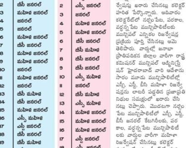
Nagaram Municipality 20 Wards Reservation list

After careful examination of the matter and in supersession of orders issued vide reference 2nd read above, Government herby decide to issue final notification of division of Nagaram Municipality into Twenty (20) wards. The following Notification will be published in an Extra-Ordinary Issue of the Telangana Gazette:
Nagaram Municipality
In exercise of the powers conferred by sub-section (1) of section 6 of the Telangana Municipalities Act No. 11 of 2019 read with Telangana Municipalities (Division of Municipalities into wards) Rules 2019, issued in G.O.Ms.No.78, Municipal Administration and Urban Development (MA) Department, Dated 29.06.2019, the Governor of Telangana hereby notify the division of Nagaram Municipality into Twenty (20) wards as described in the Annexure appended to the notification with immediate effect.
Annexure to Nagaram Municipality G.O.Ms.No.329, MA & UD (MA) Department, Dated.17.12.2019 DESCRIPTION OF WARD BOUNDARIES
WARD – 1
North It starts from Nagaram – Rampally village border near H.No:10-1-279/4 and Proceeds along municipal boundary towards East direction covering Sy.No: 452 and ends atSy.No: 454.
East It Starts from above point at Sy.No:454 Proceeds along Municipal border and Sy.No: 761 and NALAby covering Rapolu Enclave uptoH.No: 5-7-65 then Proceeds along the road up to Main road ends at H.No: 8-1-111
South It Starts from above point at H.No: 8-1-111 Proceeds along Rampally main Road towards NagaramuptoRampally village border ends at KLR land.
West It Starts from the above point at KLR land proceeds along Rampally Village border upto Municipal boundary near H.No:10-1-279/4.
WARD – 2
North It Starts from A.MahalaxmiH.No: 5-7-65 and Proceeds along Rapolu layout boundary covering old Village area & ends at Hindu Grave yard (SmashanaVatika).
East It Starts from above point at Hindu Grave yard (SmashanaVatika) Proceeds along old Village road towards south side uptoRampally main road via H.No: 5-3-1 and ends at Ambedkar Statue near H.No: 5-2-11.
South It starts from the above point nearAmbedkar Statue at H.No: 5-2-11 and Proceeds along the main road towards NagaramuptoBhagathsingh Statue nearH.No: 5-1-1
West It starts from the above point nearBhagathsingh Statue H.No: 5-1-1 and Proceeds along the road and turns towards North & ends nearA.MahalaxmiH.No: 5-7-65.
WARD – 3
North It Starts from municipal boundary at RampallyPeddaCheruvu Sy.No:389/1and proceeds along the bund upto main road near SUN beverages then proceeds towards Rampally Up to Ambedkar Statue then proceeds along the village road uptoGraveyard (SmashanaVatika)and Proceeds along the municipal boundary towards East and ends at Sy.No: 619, near Mango Garden Rampally Village boundary.
East It Starts from the above point at Sy.No:619 and Proceeds along municipal border uptoS.No 684then turns and proceeds along the municipal boundary which ends Sy.No: 692 on Ghatkesar Road then proceeds along municipal border by covering Sy.No:254 and crossing railway track ends at Sy.No: 253.
South It Starts from Sy.No: 253and proceeds along municipal border ends atSy.No:270 nearGAlL.
West It Starts from Sy.No:270 near GAIL and Proceeds along municipal boundary by crossing railway track up toRampallyPeddacheruvuSy.No: 389/1.
WARD – 4
North It Starts fromRampallymain road at Atom Energy research centre and Proceeds along main road ends uptoH.No: 9-1-1 near sun beverages water plant.
East It Starts from H.No:9-1-1 near Sun Beverages water plant Proceeds along layout road upto boundary of RampallyPeddaCheruvuSy.No: 389/1.
South It Starts from the above point Sy.No’s: 389/1 and Proceeds along the bund of RampallyPeddacheruvu ends at Sy.No: 393 and 394 of Savitri Nagar.
West It Starts from Sy.No: 393 and 394 of Savitri Nagar Proceeds along municipal boundary up to 10-3-59/4 then Proceeds forward along the Rampally Village boundary and ends at Atomic Energy Research Centre.
WARD – 5
North Starts from existing NALA on old village road near H.No:11-12/24 and proceeds along the Road uptoRampallymain road then turns towards right and Proceedson main Road ends at Atomic Energy Research Centre.
East It starts at the above pointat Atomic Energy Research Centre and proceeds along Nagaram Village boundary upto municipal boundary near H.No: 1125/2.
South It Starts from the above point and proceeds along the Municipal Boundary proceeds towards west side and ends at H.No: 11-7Lotus School.
West It starts from Lotus School and proceeds along the road covering Lotus Colony and Annamaiah Colony then turns towards west along the border of Venkat Reddy Colony upto Existing NALA and Proceeds along the NALA upto Old Village H.No:11-12/24.
WARD – 6
North It Starts from H.No: 8-1 beside Municipal office and Proceeds along the border of Vikas Nagar colony up to Vacant land near pochamma temple then turns along the vacant landcovering Modi apartmentsuptoborder of Annamaiah colony .
East It Starts from above pointnear H.No:8-245/1 Proceeds along the roadand border of Chakradara enclave ends at Lotus School.
South It Starts from opposite lotus school and Proceeds along with Municipal boundary covering Chakradhara enclave up to Sy.No: 170 vacant land then proceeds along border of Sy.No: 170 up to New Laxmi Nagar beside H.No: 8356/1 then Proceeds along vacant land of Sy.No: 206/1 along the shilpa Nagar road towards Paramount Avenue gate and Proceeds along the border of Paramount Avenue Apartments H.No: 8-295/1 upto NALA then Proceeds along the existing NALÅ up to main road culvert at Bus Stop.
West It Starts from above point NALA culvert and Proceeds along the road towards Keesara ends at H.No: 8-1 beside municipal office.
WARD – 7
North It Starts from Keesara Main Road at culvert andproceeds along the NALA upto Padmavathi Apartments H.No: 8-297 and Proceeds along the road upto Paramount Apartment Gate, then Proceeds towards East along Shilpa Nagar road upto Vacant land Sy.No: 206/1 New.H.No: 8-356/1 of Lavanya Enclave.
East It Starts near H.No: 8-356/1 Proceeds along the Lavanya Enclave boundary besides vacant land boundary of Sy.No 170 and proceeds upto municipal boundary by crossing existing NALA at Sai Nivas Colony.
South It Starts from the above point municipal boundary and SaiNivas Colony border at Sy.No: 213 and Proceeds along the municipal border uptoSy.No: 301 near Shiva Sai Function Hall.
West It Starts from Sy.No: 301 Municipal boundary and proceeds along the border of Sy.No:301 uptoH.No: 9-299 then Proceeds along the road upto vacant plot opp. H.No: 9-348 then turns and proceedsupto H.No:9-336 then turns and proceeds upto main road at Vijaya Hospital H.No: 9-889 then Proceeds along the main road upto NALA culvert.
WARD – 8
North It Starts from H.NO: 9-638 and Proceeds along the road up to dead end atH.No: 9-639 then turns along the colony border covering GuduruMalla Reddy Colony up to H.No: 9-600 then turns and Proceedsupto main road covering a corner house at main road then turns and proceeds along the Keesara main road upto vacant plot besideVijaya Hospital H.No: 9-889.
East It Starts from above point vacant land then turns behind vacant plot Proceedsupto H.NO: 9-348, then turn and Proceeds along the road uptoH.No: 9-301 and proceeds upto dead end vacant plot near H.No: 9-308 and then proceeds along the boundary of Sy.No:302upto municipal boundary
South It starts from municipal boundary at Sy.No:302 and proceeds along the Municipal boundary uptoKeesara main road at H.No:9-911.
West It Starts from H.No:9-911. Proceeds along with municipal boundary by crossing the main road proceeds uptoH.No: 9-638 opp. GHMC layout.
WARD – 9
North It starts from Municipal boundary atBhagya Nagar NALA opp. MaruthiNagar(GHMC) and Proceeds along the NALA & municipal border by covering Anna RayaniCheruvu and ends at Sy.No:379.
East It Starts from Sy.No:379 at Anna RayaniCheruvu and Proceeds along the border of existing canal ends upto culvert on KeesaraMain road near bus stop.
South It starts at NALA culvert near bus stop and Proceeds along the main road towards ECIL X roads ends at opp. H.No: 9-916.
West It starts from Opp. H.No:9-916 and Proceeds along the back side of H.No: 9600 then proceeds along thee GuduruMalla Reddy Colony boundary upto H.No:9-640 then turns proceeds along road upto municipal boundary at H.No:9-643 then turns and proceeds towards North along the municipal boundary& roaduptoMunicipal boundary atBhagya Nagar NALA opp. Maruthi Nagar(GHMC).
WARD – 10
North It Starts beside Sudhakarreddy water plantH.No: 6-53/6 and proceeds along the border of Laxmi Nagar -l & Il by coveringPochamma Temple proceeds along the border of Simhapuri Colony H.No:7-79 and ends at to Main Road Nagaramnear VenkataDatta Marble Shop.
East It starts from the above point at VenkataDatta marble shop proceeds along the main road and ends at NALA peddakappu.
South It starts from the above point and proceeds along the NALA towards west side upto Municipal Boundary.
West It starts from above point and proceeds along the Municipal boundary and ends beside Sudhakarreddy water plantH.No: 6-53/6.
WARD – 11
North It starts from Municipal boundary at Dubai building H.No: 6-51 and proceeds along the Dammaiguda main road ends at old market road opp.Fish building (near SVR Apartment H.No:6-117/1 / 2)
East Starts from vacant plot opp fish building near SVR Apartments H.No: 6-117/1 /2 and proceeds along the old market road towards south side ends at H.No: 6-116/1 of Ramalingeshwara Nagar.
South It starts from H.No: 6-116/1 Proceeds along the Ramalingeshwara Colony border and proceeds along the Navatha Avenue colony border upto H.No:6110/21
West It Starts from Navatha Avenue H.No: 6-110/21 and proceeds along theborder of Navatha avenue uptosudhakar Reddy water plant H.No: 6-53/4/4 then turns towards south side upto Municipal boundary near H.No: 6-17 then Proceeds along the municipal boundary ends at Dubai Building at H.No: 6-51
WARD – 12
North It starts beside old Market road from vacant land Sy.No: 628. Opposite fish building and proceeds along the Dammaiguda road ends at Dammaiguda X roads near H.No: 6-636
East It Starts from Dammaiguda X roads Near H.No:6-636 and proceeds along the Keesara main Road towards ECIL X road and ends at Masjid.
South It starts from Masjid and proceeds along the road towards west uptoH.No:6-139/2 and Proceeds along the vacant land of (Sathireddy& others) upto H.No: 6-155/2 then proceeds along the road ends at H.No:6-156
West It Starts from H.No:6-156 then proceeds along the boundary of venkateshwara Nagar colony layout uptoH.No: 6-147 then Proceeds forward along the Teachers Colony border uptoH.No: 6-145/9/4, then turns towards East along Teachers colony uptoH.No: 6-141 / 2 then turns towards North upto Vacant land opposite fish building along old market road
WARD – 13
North It starts from Krishna Theatre near H.No: 5-91 and Proceeds along the municipal boundary ends at H.No: 5-2/2/4 ofBhavani Nagar and proceeds towards main road ends near H.No: 5-2/4
East It Starts from the above point near H.No:5-2/4 and proceeds towards main road uptoSubashreddyhouse H.No:5-21 at Dammaiguda X road.
South It Starts from Dammaiguda X roads near Subashreddy house H.No:5-21 proceeds along the Dammaiguda road ends at Dattatreya Nagar nearH.No: 5-105
West It Starts from the above point H.No: 5-105 proceedstowards Northends at Krishna Theatre House No: 5-91.
WARD – 14
North It Starts from H.No:4-10 and Proceeds along the Municipal Boundary uptoKeesara main road near H.No: 4-54/4 and proceeds along the Keesara Road uptoH.No: 4-45/5/2 then turns left along the Municipal Boundary ends at H.No: 4-47/2 on Keesara Road opposite round building.
East It starts from H.No: 4-47/2 and proceeds along the Municipal Boundary covering Santosh Nagar layout along Prajasai road and turns along Municipal Boundary covering upto Indira PriyaDarshini Colony at Sy.No:83 boundary.
South It starts from Sy.No:83, proceeds along vacant land of Sy.No.85 then turns towards North along the Sy.No: 86 then turns towards west side along the I.Comm factory covering naaskunta proceeds towards North uptoTswr school of fine artsKeesara Main Road ends at Rampally X roads at H.No: 4-1 (Balaji Sweet House)
West It Starts from H.No: 4-1 (Balaji Sweet House) Proceeds along the road side houses uptoH.No: 4-8/26 Anganwadi then turns along Municipal Border ends at H.No:4-10
WARD – 15
North It Starts from keesara main road at TSWR School of fine arts collage Keesara Main Road and proceeds turns and proceeds along thekunta boundary to I-Comm compound Wall uptoH.No: 4-61/9
East It Starts from the above point at H.No: 4-61/9 behind I Comm compound wall proceeds along the prashanthnagar road towards Rampally main road near H.No 4-88/18
South It Starts from the above point at H.No.4-88/18 on main road and proceeds Rampally main road up to Rampally -Keesara X Road near H.No:4-76/2 (V.Mahendar Reddy House)
West It starts from the above point near H.No: 4-76/2 Proceeds along the Keesaramain road towards ends at TSWR School of fine arts collage
WARD – 16
North It Starts behind l.Comm compound wallnear H.No: 10-825/9 and Proceeds along the compound wall up to municipal boundary at Pudami SchoolH.No:12-50
East It Starts from Pudami School H.No: 12-50 Sy.No:93 proceeds upto NallaPochamma Temple near H.No: 12-1 and proceeds along the Nagaram village boundary upto Rampally main road near H.No:12-47
South It starts from H.No: 12-47 on Rampally main road and proceeds along the main road towards west side ends at H.No:10-600 of Netaji Nagar
West It starts from H.No:10-600 Proceeds along the Netaji Nagar road l.Comm Compound wall near H.No: 10-825/9.
WARD – 17
North It Starts from H.No:10-170 and proceeds along the Friday market road ends at Rampally main road at H.No: 10-79/49/5.
East It starts from H.No: 10-79/49/5 on Rampallymainroad towards Rampallyupto H.No:10-543 near old village road.
South It starts from H.No: 10-543 at main road and Proceeds along the old village road upto NALA near SC community hall near H.No:10-1.
West It starts from H.No: 10-1 near SC community hall and Proceeds along the SC quarters and Bhagya Nagar Colony uptoH.No: 10-170 near Mathman School.
WARD – 18
North It Starts from Keesara main road from H.No: 1-10 (Heritage milk point) and
Proceeds along the old village upto H.No:1-100 and Proceeds along the Aravind Nagar road uptoH.No: 1-102/2 then Proceeds along the road uptoH.No: 1-105 then forwards uptoMathman School road ends atH.No: 1103/8
East It Starts from H.No: 1-103/8 it Proceeds along the road towards south side upto old Village and at NALÅ near H.No: 1-101 / 1 then turns towards the West and proceeds along the NALA upto Sy.No: 184
South It Starts from Sy.No: 184 Road Proceeds along the boundary of Sy.No: 199 along the Sai Durga Colony Layout and Modi apartment border upto New Pochamma Temple and proceeds along the boundary of old Village (Gramakantam) upto Municipal Office.
West It Starts from Municipal Office building and Proceeds along Keesara Main Road upto H.No: 1-10 (Heritage Milk Point).
WARD – 19
North It Starts from H.No: 2-88 on main road and Proceeds along the old Village towards Kota Maisamma Temple and along the road upto Devetalabavi and then Proceeds along the road and the bund of Dayarakunta and ends at H.No:1-103/31 near Mathman School.
East It Starts from H.No: 1-103/31 and Proceeds along the road uptoH.No: 1103/25 then turns towards west uptoH.No: 1-105/88/1 then turns along road ends at sy.No:126
South It Starts from Sy.No:126 and Proceeds along the road uptoSy.No: 116 H.No: 1-121 / 2 then turns upto Arvind Nagar Community Hall along the boundary of Pavan Nagar along the road via Hanuman Temple which ends at H.No: 2-97 on Keesara main road.
West It Starts from H.N02-97 and Proceeds along the Keesara main road towards Keesara and ends at H.No:2-88.
WARD – 20
North East It Starts from Rampally X road at H.No: 4-108 and Proceeds along the Rampally main road upto Friday Market Road near H.No: 10-19/28/5
South It starts from the above point H.No: 10-19/28/5 and Proceeds along the Friday market road uptoSy.No: 113 near H.No: 3-1 via tank bund, then turns along the Kota Maisamma temple which Proceeds along lane upto PAI show room H.No:3-42.
West It starts from H.No: 3-42 PAI Showroom and Proceeds along Keesara main road uptoRampally X road at H.No: 4-108.
How many municipalities are there in Malkajgiri District
In Medchal Malkajgiri there are total 9 municipalities, namely Medchal, Dammaiguda, Nagaram, Pocharam, Ghatkesar, Gundla Pochampalli, Tumkunta, Kompally, Dundigal
How many Municipality are there in Telangana
The state of Telangana has a total of 128 municipalities
How many Municipal Corporations in telangana
There are total 13 Municipal Corporations are there in Telangana State. The List of Municipal Corporations are Hyderabad, Warangal Urban, Nizamabad, Khammam, Karimnagar, Ramagundam, Badangpet, Bandlaguda Jagir, Meerpet Jillelguda, Boduppal, Peerzadiguda, Jawaharnagar and Nizampet
How many wards in Nagaram Municipality
There are total 20 Municipal wards in Nagaram Municipality