


Kosgi, a vibrant town nestled in the heart of Telangana’s Narayanpet district, stands as a testament to India’s evolving local governance system. In 2019, the town underwent a significant transformation through the delimitation of its municipal wards, paving the way for fairer elections and better representation. This process divided Kosgi Municipality into 16 wards, incorporating merged areas and ensuring equitable distribution based on population and demographics. As Telangana continues to modernize its urban local bodies (ULBs), understanding this delimitation offers insights into how small towns like Kosgi contribute to the state’s democratic fabric. This article explores the intricacies of the 2019 ward division, its historical context, reservations for marginalized groups, and its lasting impact on local elections and community development in Narayanpet.
The Evolution of Narayanpet District: From Historical Roots to Modern Telangana
Narayanpet district, where Kosgi serves as a key municipality, traces its origins to ancient times, weaving through the tapestries of various dynasties that shaped southern India. Historians note that the region, once part of the larger Mahabubnagar district, fell under the influence of the Nandas, Mauryas, Satavahanas, and Ikshvakus before coming under medieval rulers like the Kakatiyas and the Qutb Shahis. During the British era, it integrated into the Hyderabad State, and post-independence, it became a cornerstone of Telangana’s administrative landscape.
The district officially formed on February 17, 2019, as part of Telangana’s ambitious reorganization of districts, carving out areas from the erstwhile Mahabubnagar to create a more manageable administrative unit. Spanning approximately 2,336 square kilometers, Narayanpet boasts a population of around 566,874 as per the 2011 Census, with a near-equal gender split—282,231 males and 284,643 females. The literacy rate hovers at 49.93%, reflecting ongoing efforts in education and development. Demographically, the district features a mix of rural and urban populations, with agriculture dominating the economy through crops like paddy, cotton, and groundnut. However, Narayanpet’s true fame lies in its exquisite handloom sarees, a craft passed down through generations, making it a hub for textile artisans.
Kosgi town itself embodies this blend of tradition and progress. With a population of about 21,038 in 2001, which has likely grown since, Kosgi covers a modest area but pulses with community life. Located roughly 45 kilometers north of Mahabubnagar and accessible via state highways, the town forms part of the Kodangal assembly constituency. Residents engage in farming, handlooms, and small-scale trade, with landmarks like local temples and markets adding cultural depth. The establishment of Kosgi as a municipality under Telangana’s Municipal Administration and Urban Development (MA&UD) Department marked a shift toward structured urban governance, enabling better infrastructure like roads, water supply, and sanitation.
This historical backdrop sets the stage for the 2019 ward delimitation, which aligned with Telangana’s broader push for decentralized democracy. As the state government restructured districts and ULBs, Kosgi’s transformation ensured that local voices, from farmers in Pothireddy Pally to artisans in Harijan Wada, gained stronger representation in municipal decisions.
Understanding Ward Delimitation: Why It Matters in Indian Municipalities
Ward delimitation represents a cornerstone of democratic fairness in India’s urban governance. This process redraws electoral boundaries within municipalities to reflect population changes, ensuring each ward has roughly equal voters and preventing imbalances that could skew representation. In essence, delimitation promotes inclusive participation, allowing diverse communities to elect councilors who address local issues like waste management, street lighting, and public health.
The Constitution (74th Amendment) Act of 1992 empowered municipalities by mandating regular elections, reservations for Scheduled Castes (SC), Scheduled Tribes (ST), Backward Classes (BC), and women, and the formation of ward committees. This amendment decentralized power from state governments to local bodies, fostering grassroots decision-making. In practice, delimitation commissions or authorities use census data to adjust boundaries, incorporating natural features like roads or rivers for logical divisions.
In Telangana, the importance of delimitation amplified during the 2019-2020 municipal elections. The state, formed in 2014, inherited a legacy of uneven urban development from Andhra Pradesh. To address this, the Telangana government issued ordinances and G.O.s (Government Orders) to reorganize ULBs. For instance, Extraordinary Ordinance No. 4 of June 28, 2019, and subsequent orders like G.O. Rt. No. 459 and G.O. Ms. No. 78 from the MA&UD Department, standardized ward divisions across municipalities. These measures aimed to integrate merged villages into urban frameworks, boosting efficiency in service delivery.
Delimitation’s benefits extend beyond elections. It curbs gerrymandering—manipulating boundaries for political gain—and ensures proportional reservations. In diverse societies like India’s, this safeguards marginalized groups’ interests. For example, reserving wards for women empowers female leaders to tackle gender-specific issues like maternal health and education. Critics, however, argue that rushed delimitations can overlook community ties, leading to fragmented neighborhoods. Despite this, the process strengthens local democracy, as seen in Kosgi, where the 2019 exercise balanced voter strengths across 16 wards, averaging about 1,000-1,100 voters each.
Nationally, delimitation draws parallels with parliamentary constituency redraws, last conducted in 2002 based on the 1971 Census. Delays in updating these, due to population control incentives, highlight the need for timely municipal adjustments. In urban India, where cities swell rapidly, regular delimitation prevents overburdened wards and promotes sustainable development. For Telangana’s smaller towns like Kosgi, it means better access to funds under schemes like Swachh Bharat Mission, where Narayanpet district has achieved high marks in waste collection and segregation.
The 2019 Delimitation Process in Kosgi Municipality: A Step-by-Step Breakdown
In December 2019, Kosgi Municipality’s Commissioner, Samuel John, spearheaded the draft proposals for re-dividing the town into 16 wards. This initiative complied with directives from the Commissioner & Director of Municipal Administration (CDMA) in Hyderabad. The letter, dated December 3, 2019 (Lr. No. Roc No. MCK/82/2019), referenced key government orders, including G.O. Rt. No. 795 from the MA&UD Department.
Authorities submitted the draft to officials like the Revenue Divisional Officer in Narayanpet, the Tahsildar in Kosgi, and the Municipal Office Notice Board. They also copied higher-ups, such as the District Collector and Regional Director of Municipal Administration, for transparency. The process incorporated voter particulars, locations, and a prescribed proforma, displaying the delimitation on notice boards to invite public feedback.
This delimitation integrated merged areas, expanding Kosgi’s urban footprint. It drew from the 2011 Census and recent voter rolls, aiming for balanced wards. The total voter base hovered around 16,000-17,000, distributed to avoid disparities. Block-wise house numbers guided the divisions, ensuring wards encompassed coherent communities.
The exercise aligned with Telangana’s statewide municipal polls in January 2020, where 121 municipalities and 10 corporations elected representatives. In Kosgi, it set the foundation for electing 16 ward members, who form the municipal council alongside a chairperson. This council handles budgets, infrastructure projects, and community welfare, directly impacting residents’ lives.
Post-delimitation, elections proceeded smoothly, with parties like the Telangana Rashtra Samithi (TRS, now BRS) dominating in rural belts. Kosgi’s process exemplified efficient administration, with no major controversies reported. Today, in 2026, these wards continue to function, though periodic reviews might adjust for population growth.
Detailed Breakdown of Kosgi’s 16 Wards: Areas, House Numbers, and Voter Strengths
Kosgi’s 16 wards showcase the town’s diverse neighborhoods, from agricultural pockets to bustling market areas. Each ward features specific block-wise house numbers, voter strengths, and named areas, as outlined in the 2019 delimitation table. This section details them to provide a clear map for residents and researchers.
Ward 1 covers Pothireddy Pally Part 1, including BC Colony, OC Colony, and SC Colony. House numbers range from 1-1 to 1-191, 2-33 to 2-181, 3-1 to 3-84, 4-1 to 4-61, and 4-127 to 4-141. With 1,138 voters, this ward represents a mix of castes and occupations, centered around rural livelihoods.
Ward 2 includes Gundla Pally, Pothireddy Pally Part 2 (with a school and Anganwadi Kendra), Maseed Area, BC Colony, and Gundlapally (253 voters). House ranges: 1-2 to 1-193, 2-1 to 2-45, 4-62 to 4-126. Voter strength stands at 1,137, highlighting educational facilities as key landmarks.
Ward 3 encompasses Mal Reddy Pally and Thimmaipally, with houses from 1-1 to 1-100, 2-1 to 2-63, and 3-1 to 3-100. At 1,035 voters, it focuses on agricultural communities.
Ward 4 spans Sampally, Kosgi Sub Station area, and Teachers Colony Part, including 1st Block Part Kosgi. Houses: 1-1 to 1-100. Voter count: 1,115.
Ward 5 covers Masai Pally and Nagasam Pally, with ranges 1-1 to 1-100, 2-1 to 2-91, 3-1 to 3-99, 4-1 to 4-42. Voters: 1,132.
Ward 6 includes Sai Nagar Colony, MPDO Office area, BC Colony (Sriram Colony and SC Colony), from 20 Block Part 2, 21-1 to 21-132, 22-01 to 22-110. Voter strength: 1,132.
Ward 7 features BC Colony Kosgi and Tandur Road Market Area, from 20 Block Part 1 and 16-01 to 16-129. Voters: 1,033.
Ward 8 comprises Pinjari Galli, Golla Veedhi, and Munnur Veedhi, houses 17-01 to 17-122 and 14-1 to 14-148. With 1,136 voters.
Ward 9 includes Brahmanwada, Thunki Galli, and Gudepu Veedi, from 15-1 to 15-129 and 7-1 to 7-144. Voters: 1,033.
Ward 10 covers Harijan Wada and Telugu Veedhi, including 9th Block Part, houses 8-1 to 8-140. Voter count: 1,038.
Ward 11 spans Baharpet and Maamilla Veedi, from 3-1 to 3-150 and 4-1 to 4-152. Voters: 1,060.
Ward 12 includes Golla Veedi, Vinayaka Nagar, and Pochamma Temple Area, houses 5-1 to 5-152 and 6-1 to 6-150. With 1,032 voters.
Ward 13 covers Adike Veedhi and Teachers Colony, from 1-1 to 1-150 and 2-1 to 2-150. Voters: 1,040.
Ward 14 includes Hatkargalli, GP Roads, Chakali Veedhi, and Munnur Veedhi, houses 18-1 to 18-133 and 19-1 to 19-151. Voter strength: 1,040.
Ward 15 spans Devidi Area, Kummari Veedi, Mangali Veedi, and Urdu Medium School Area, from 12-1 to 12-176/1 and 13-1 to 13-136. Voters: 1,138.
Ward 16 covers Telugu Veedhi and Mominpet, including 9th Block Part, 10-1 to 10-106/1, 11-1 to 11-148. With 1,093 voters.
These divisions ensure comprehensive coverage, with total voters approximating 17,000, promoting targeted development.
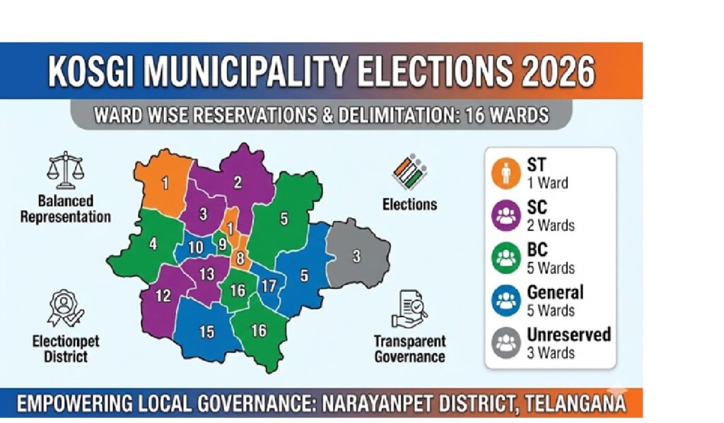
Reservations in Kosgi Wards: Promoting Inclusivity and Equity
Reservations form the bedrock of social justice in Kosgi’s municipal setup. The 2019 schedule allocated seats across categories to uplift underrepresented groups.
For Scheduled Tribes (ST), authorities reserved one general ward (Ward 3.2: 4), with no women’s reservation. Scheduled Castes (SC) received three wards: one for women (Ward 4.1: 1) and two general (Ward 4.2: 3, possibly another). Backward Classes (BC) saw substantial allocation: five for women (Ward 5.1: 6, 13) and seven for general (Ward 5.2: 7, 9, 12). Women in general categories got three wards (Ward 4: 2), while general unreserved wards numbered five (Ward 6: 5). Unreserved wards for women included 5, 8, 15.
This matrix followed Telangana’s reservation policy, drawing lots for specific allotments. In the 2020 elections, it ensured diverse council composition, with women comprising about 50% of seats statewide. In Kosgi, reservations empowered BC-dominated areas like Sai Nagar Colony and SC colonies in Pothireddy Pally.
Statewide, Telangana reserved mayor/chairperson posts via G.O. Ms. No. 7, allocating to ST/SC/BC/women. This fostered inclusive policies, like women’s self-help groups in handlooms.
Voter Demographics and Their Role in Shaping Local Governance
Kosgi’s voter demographics mirror Narayanpet’s rural-urban mix. With a sex ratio near parity and literacy at 50%, voters prioritize agriculture, education, and infrastructure. Ward-wise strengths range from 1,032 to 1,138, ensuring balanced influence.
The 2019 delimitation used 2011 Census data, updated with electoral rolls. Merged areas added voters from villages, boosting participation. In 2020 polls, turnout exceeded 60%, reflecting engagement.
Demographics influence priorities: BC-heavy wards focus on subsidies, while SC/ST areas emphasize welfare. This shapes council agendas, from road repairs in market wards to schools in colony areas.
The Lasting Impact of Delimitation on Kosgi’s Future
The 2019 delimitation has strengthened Kosgi’s governance, enabling schemes like AMRUT for water and PMAY for housing. It sets a model for other Telangana municipalities, emphasizing transparency.
Looking ahead, with Narayanpet’s growth in textiles, wards may need re-delimitation post-2021 Census. Challenges like migration require adaptive boundaries.
In conclusion, Kosgi’s ward division exemplifies democracy’s grassroots power, fostering equitable development in Telangana’s heartland.